Geographic Region: GULF OF MEXICO
Feature: PAN- TEXAS CITIES AT NIGHT, MOON GLINT
|
Geographic Region: GULF OF MEXICO Feature: PAN- TEXAS CITIES AT NIGHT, MOON GLINT |
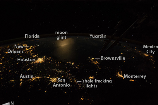 |
| Texas at night This wide-angle, nighttime image was taken by astronauts looking from the International Space Station out southeastward over the Gulf of Mexico. Moonlight reflects diffusely off the waters of the gulf (image center left) making the largest illuminated area in the image. The sharp edge of light patterns of coastal cities trace out the long curve of the gulf shoreline!afrom New Orleans at the mouth of the Mississippi River, to Houston (both image left), to Brownsville (image center) in the westernmost gulf. City lights at great distances in Florida (image top left) and on Mexico!-s Yucat"C/n peninsula (image center right) suggest the full extent of the gulf basin (more than 1500 km, or 930 miles, from Brownsville to Florida). Other city patterns are the arcing string of lights of the Austin"CSan Antonio conurbation in central Texas, and Mexico!-s first and second cities, Mexico City and Monterrey (image right). In recent years a new pattern of lights has appeared revealing the oil- and gas-production zone of south-central Texas"Dhere a long, less dense swath of pinpoints (image lower center) shows the 330 km extent of what is now known now as shale fracking country. |
| Images: | All Available Images Low-Resolution 79k |
|
| Mission: | ISS042 |
|
| Roll - Frame: | E - 241898 |
|
| Geographical Name: | GULF OF MEXICO |
|
| Features: | PAN- TEXAS CITIES AT NIGHT, MOON GLINT |
|
| Center Lat x Lon: | 25.0N x 95.5W |
|
| Film Exposure: | N=Normal exposure, U=Under exposed, O=Over exposed, F=out of Focus |
|
| Percentage of Cloud Cover-CLDP: | 0 |
|
| Camera:: | N6 |
|
| Camera Tilt: | HO | LO=Low Oblique, HO=High Oblique, NV=Near Vertical |
| Camera Focal Length: | 20 |
|
| Nadir to Photo Center Direction: | SE | The direction from the nadir to the center point, N=North, S=South, E=East, W=West |
| Stereo?: | Y=Yes there is an adjacent picture of the same area, N=No there isn't |
|
| Orbit Number: | |
|
| Date: | 20150211 | YYYYMMDD |
| Time: | 070858 | GMT HHMMSS |
| Nadir Lat: | 30.8N |
Latitude of suborbital point of spacecraft |
| Nadir Lon: | 103.6W |
Longitude of suborbital point of spacecraft |
| Sun Azimuth: | 0 | Clockwise angle in degrees from north to the sun measured at the nadir point |
| Space Craft Altitude: | 217 | nautical miles |
| Sun Elevation: | -73 | Angle in degrees between the horizon and the sun, measured at the nadir point |
| Land Views: | PENINSULA |
|
| Water Views: | GULF |
|
| Atmosphere Views: | |
|
| Man Made Views: | |
|
| City Views: | AUSTIN, BROWNSVILLE, HOUSTON, MEXICO CITY, MONTERREY, NEW ORLEANS |
|
Photo is not associated with any sequences | ||
| NASA Home Page |
JSC Home Page |
JSC Digital Image Collection |
Earth Science & Remote Sensing |
|
This service is provided by the International Space Station program and the JSC Earth Science & Remote Sensing Unit, ARES Division, Exploration Integration Science Directorate.

|