Geographic Region: UKRAINE
Feature: PAN-POLAR MESOSPHERIC CLOUDS, SUNSET
|
Geographic Region: UKRAINE Feature: PAN-POLAR MESOSPHERIC CLOUDS, SUNSET |
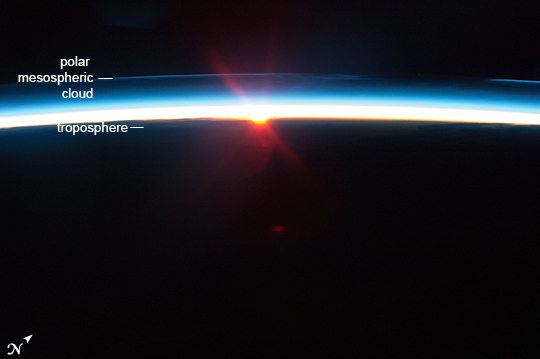 |
| Polar Mesospheric Clouds ("PMC"), Russia This image of mesospheric clouds was taken by astronauts when the International Space Station was flying over the Volga River in Russia. Whispy and hard to see, PMC form far above the usual level for clouds, 80-100 km above the ground, so that crews flying at ~350 km are ideally placed to observe them. PMC usually only appear near the poles, but during the past few decades they have appeared as far south as Colorado and Virginia in the USA. They also appear brighter and thicker. Scientists think that these changes are related to long-term climate change, perhaps from increasing water vapor content in the upper atmosphere. This sunset shot shows the PMC as a thin bright line -- far above the lowest, yellow-brown weather layer of the atmosphere (known as the troposphere). |
| Images: | All Available Images Low-Resolution 118k |
|
| Mission: | ISS040 |
|
| Roll - Frame: | E - 87351 |
|
| Geographical Name: | UKRAINE |
|
| Features: | PAN-POLAR MESOSPHERIC CLOUDS, SUNSET |
|
| Center Lat x Lon: | N x E |
|
| Film Exposure: | N=Normal exposure, U=Under exposed, O=Over exposed, F=out of Focus |
|
| Percentage of Cloud Cover-CLDP: | 0 |
|
| Camera:: | N5 |
|
| Camera Tilt: | HO | LO=Low Oblique, HO=High Oblique, NV=Near Vertical |
| Camera Focal Length: | 85 |
|
| Nadir to Photo Center Direction: | The direction from the nadir to the center point, N=North, S=South, E=East, W=West |
|
| Stereo?: | Y=Yes there is an adjacent picture of the same area, N=No there isn't |
|
| Orbit Number: | |
|
| Date: | 20140801 | YYYYMMDD |
| Time: | 204928 | GMT HHMMSS |
| Nadir Lat: | 50.8N |
Latitude of suborbital point of spacecraft |
| Nadir Lon: | 45.1E |
Longitude of suborbital point of spacecraft |
| Sun Azimuth: | 356 | Clockwise angle in degrees from north to the sun measured at the nadir point |
| Space Craft Altitude: | 222 | nautical miles |
| Sun Elevation: | -21 | Angle in degrees between the horizon and the sun, measured at the nadir point |
| Land Views: | |
|
| Water Views: | |
|
| Atmosphere Views: | |
|
| Man Made Views: | |
|
| City Views: | |
|
Photo is not associated with any sequences | ||
| NASA Home Page |
JSC Home Page |
JSC Digital Image Collection |
Earth Science & Remote Sensing |
|
This service is provided by the International Space Station program and the JSC Earth Science & Remote Sensing Unit, ARES Division, Exploration Integration Science Directorate.

|