Geographic Region: ISRAEL
Feature: TEL AVIV-JERUSALEM-AMMAN-BEERSHEBA AREA AT NIGHT
|
Geographic Region: ISRAEL Feature: TEL AVIV-JERUSALEM-AMMAN-BEERSHEBA AREA AT NIGHT |
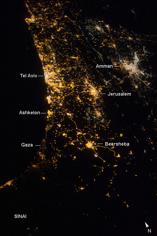 |
| Eastern Mediterranean coastline at night This night image recently shot by astronauts aboard the International Space Station (ISS) vividly shows the location and size of cities at the east end of the Mediterranean Sea. The largest, brightest cluster is the Israeli city of Tel Aviv (lower center left), a port set against the blackness of the Mediterranean Sea. Jerusalem, Israel's capital city (upper center left), and Amman, Jordan's capital (top left), are the next largest (with Amman's lights a whiter tone), followed by Beersheba. Highway lights mark narrow lines that snake between these cities. The mainly dark areas with small towns are agricultural and pastoral areas of Israel, Sinai, Gaza, the West Bank and Jordan. The long valley of the Jordan River and the Dead Sea is suggested by the wide almost black zone between Jerusalem and Amman that trends left to right across the entire image. |
| Images: | All Available Images Low-Resolution 152k |
|
| Mission: | ISS040 |
|
| Roll - Frame: | E - 74022 |
|
| Geographical Name: | ISRAEL |
|
| Features: | TEL AVIV-JERUSALEM-AMMAN-BEERSHEBA AREA AT NIGHT |
|
| Center Lat x Lon: | 31.6N x 34.8E |
|
| Film Exposure: | N=Normal exposure, U=Under exposed, O=Over exposed, F=out of Focus |
|
| Percentage of Cloud Cover-CLDP: | 0 |
|
| Camera:: | N5 |
|
| Camera Tilt: | 40 | LO=Low Oblique, HO=High Oblique, NV=Near Vertical |
| Camera Focal Length: | 85 |
|
| Nadir to Photo Center Direction: | NE | The direction from the nadir to the center point, N=North, S=South, E=East, W=West |
| Stereo?: | Y=Yes there is an adjacent picture of the same area, N=No there isn't |
|
| Orbit Number: | |
|
| Date: | 20140722 | YYYYMMDD |
| Time: | 222513 | GMT HHMMSS |
| Nadir Lat: | 29.8N |
Latitude of suborbital point of spacecraft |
| Nadir Lon: | 32.3E |
Longitude of suborbital point of spacecraft |
| Sun Azimuth: | 9 | Clockwise angle in degrees from north to the sun measured at the nadir point |
| Space Craft Altitude: | 223 | nautical miles |
| Sun Elevation: | -40 | Angle in degrees between the horizon and the sun, measured at the nadir point |
| Land Views: | |
|
| Water Views: | |
|
| Atmosphere Views: | |
|
| Man Made Views: | HIGHWAY |
|
| City Views: | AMMAN, GAZA, JERUSALEM, TEL AVIV |
|
Photo is not associated with any sequences | ||
| NASA Home Page |
JSC Home Page |
JSC Digital Image Collection |
Earth Science & Remote Sensing |
|
This service is provided by the International Space Station program and the JSC Earth Science & Remote Sensing Unit, ARES Division, Exploration Integration Science Directorate.

|