Geographic Region: MEXICO
Feature: CANCUN, CORAL REEFS, LAGOONS
|
Geographic Region: MEXICO Feature: CANCUN, CORAL REEFS, LAGOONS |
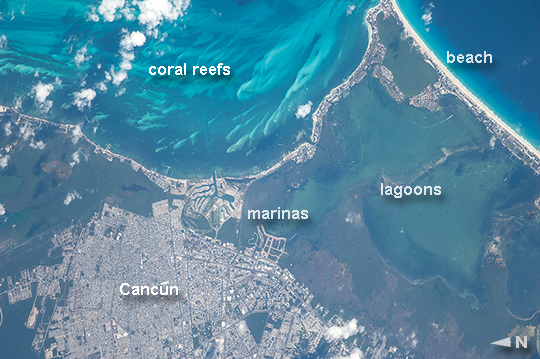 |
| Cancun, Mexico A long lens was used by astronauts aboard the International Space Station to take this image, and it highlights many natural and built features. The street pattern of Mexico's tourist mecca, Cancun, contrasts with the waterways of the marinas that open into the bay and the lagoons. Brilliant blue water over coral reefs contrasts with the dark waters of inland lagoons. The reefs are the second largest reef system on Earth, and draw tourists from all over the world. The wide, well developed beach on the gulf coast (image upper right) is the result of vigorous wave energy, its white sand making it easily visible from space. But wave energy is reduced along Cancun's protected shoreline (image center) and the beaches are thin or non-existent. Fair-weather cumulus clouds are scattered across the image top left. To shoot crisp mages with long lenses, astronaut photographers must learn to brace themselves against the ISS bulkhead to prevent any slight shaking that would blur or "smear" the picture. Counterintuitively, they then need to move the camera carefully retaining the target at the same point in the viewfinder (the landscape moves across the viewfinder quickly with long lenses). This is called tracking the target and requires good coordination by the photographer--again, to prevent blurring. Shorter lenses do not require this skill because the image appears to pass more slowly across the viewfinder. |
| Images: | All Available Images Low-Resolution 270k |
|
| Mission: | ISS040 |
|
| Roll - Frame: | E - 112662 |
|
| Geographical Name: | MEXICO |
|
| Features: | CANCUN, CORAL REEFS, LAGOONS |
|
| Center Lat x Lon: | 21.1N x 86.8W |
|
| Film Exposure: | N=Normal exposure, U=Under exposed, O=Over exposed, F=out of Focus |
|
| Percentage of Cloud Cover-CLDP: | 10 |
|
| Camera:: | N2 |
|
| Camera Tilt: | 35 | LO=Low Oblique, HO=High Oblique, NV=Near Vertical |
| Camera Focal Length: | 800 |
|
| Nadir to Photo Center Direction: | S | The direction from the nadir to the center point, N=North, S=South, E=East, W=West |
| Stereo?: | Y=Yes there is an adjacent picture of the same area, N=No there isn't |
|
| Orbit Number: | |
|
| Date: | 20140830 | YYYYMMDD |
| Time: | 143504 | GMT HHMMSS |
| Nadir Lat: | 23.7N |
Latitude of suborbital point of spacecraft |
| Nadir Lon: | 86.6W |
Longitude of suborbital point of spacecraft |
| Sun Azimuth: | 100 | Clockwise angle in degrees from north to the sun measured at the nadir point |
| Space Craft Altitude: | 222 | nautical miles |
| Sun Elevation: | 42 | Angle in degrees between the horizon and the sun, measured at the nadir point |
| Land Views: | COAST |
|
| Water Views: | BAY, GULF, REEF |
|
| Atmosphere Views: | |
|
| Man Made Views: | |
|
| City Views: | |
|
Photo is not associated with any sequences | ||
| NASA Home Page |
JSC Home Page |
JSC Digital Image Collection |
Earth Science & Remote Sensing |
|
This service is provided by the International Space Station program and the JSC Earth Science & Remote Sensing Unit, ARES Division, Exploration Integration Science Directorate.

|