Geographic Region: JAPAN
Feature: COASTLINE, AGR. UNDER SNOW,TOKACHI R.
|
Geographic Region: JAPAN Feature: COASTLINE, AGR. UNDER SNOW,TOKACHI R. |
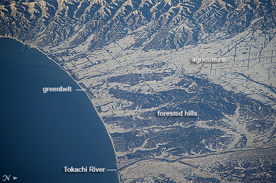 |
| Hokkaido agriculture, Northern Japan Unusually heavy snows fell on northern Japan this winter. Snow highlights the flat, fenced landscape used for agriculture in this image taken from the International Space Station. The large Tokachi River reaches the arc of the Pacific Ocean on Hokkaido's east coast. Forests on steeper hillsides mask the snow and appear dark (upper image margin and image center). This detailed view taken with a long lens from more than 800 km (500 mi) away, shows the narrow greenbelt forests that line the coast. Planted in Japan for at least the last four centuries, greenbelts protect coastlines from storms and sand movement, and are increasingly providing recreation areas. Greenbelts also reduce tsunami wave energy, protecting houses and roads from floating debris. Greenbelt forests reduced the destructive effects of the 2011 tsunami at Sendai by "catching" entire seagoing vessels, preventing them from being washed inland. |
| Images: | All Available Images Low-Resolution 388k |
|
| Mission: | ISS039 |
|
| Roll - Frame: | E - 3841 |
|
| Geographical Name: | JAPAN |
|
| Features: | COASTLINE, AGR. UNDER SNOW,TOKACHI R. |
|
| Center Lat x Lon: | 42.5N x 143.4E |
|
| Film Exposure: | N=Normal exposure, U=Under exposed, O=Over exposed, F=out of Focus |
|
| Percentage of Cloud Cover-CLDP: | 10 |
|
| Camera:: | N5 |
|
| Camera Tilt: | HO | LO=Low Oblique, HO=High Oblique, NV=Near Vertical |
| Camera Focal Length: | 800 |
|
| Nadir to Photo Center Direction: | SW | The direction from the nadir to the center point, N=North, S=South, E=East, W=West |
| Stereo?: | Y=Yes there is an adjacent picture of the same area, N=No there isn't |
|
| Orbit Number: | |
|
| Date: | 20140321 | YYYYMMDD |
| Time: | 213410 | GMT HHMMSS |
| Nadir Lat: | 47.1N |
Latitude of suborbital point of spacecraft |
| Nadir Lon: | 151.6E |
Longitude of suborbital point of spacecraft |
| Sun Azimuth: | 107 | Clockwise angle in degrees from north to the sun measured at the nadir point |
| Space Craft Altitude: | 221 | nautical miles |
| Sun Elevation: | 16 | Angle in degrees between the horizon and the sun, measured at the nadir point |
| Land Views: | COAST |
|
| Water Views: | OCEAN, RIVER |
|
| Atmosphere Views: | |
|
| Man Made Views: | AGRICULTURE |
|
| City Views: | |
|
Photo is not associated with any sequences | ||
| NASA Home Page |
JSC Home Page |
JSC Digital Image Collection |
Earth Science & Remote Sensing |
|
This service is provided by the International Space Station program and the JSC Earth Science & Remote Sensing Unit, ARES Division, Exploration Integration Science Directorate.

|