
Geographic Region: USA-WISCONSIN
Feature: GREEN BAY, LAKE ICE, FOX RIVER
|
Geographic Region: USA-WISCONSIN Feature: GREEN BAY, LAKE ICE, FOX RIVER |
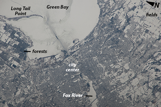 |
| Green Bay, Wisconsin, USA Note: This caption refers to the image versions labeled "NASA's Earth Observatory web site". This image taken from the International Space Station shows the city of Green Bay at the southern end of icebound Green Bay, Wisconsin. This arm of Lake Michigan is six miles wide as seen in this view. The heavy snowfalls of the winter of 2014 cover the landscape. Combined with low sun illumination of a winter's day, all surfaces appear shades of gray. Fields appear brighter (top right, lower right), the cityscape (lower half of the image) appears as a checkerboard of grays, and forests (top left) appear dark. The center of the city lies on the Fox River, one of the few larger rivers in the United States that flows north. Open water appears as dark patches at the mouth of the river where a power station emits warm water. Thinner (grayer) ice can be detected where slightly warmer water extends from the river mouth towards Long Tail Point, an ancient shoreline of the bay. Crews aboard the ISS do not usually take such detailed photographs because of the difficulty of getting sharp images with long lenses (in this case a 1000 mm lens). Streets and bridges crossing the Fox River appear quite clearly. |
| Images: | All Available Images Low-Resolution 294k |
|
| Mission: | ISS038 |
|
| Roll - Frame: | E - 57979 |
|
| Geographical Name: | USA-WISCONSIN |
|
| Features: | GREEN BAY, LAKE ICE, FOX RIVER |
|
| Center Lat x Lon: | 44.5N x 88W |
|
| Film Exposure: | N=Normal exposure, U=Under exposed, O=Over exposed, F=out of Focus |
|
| Percentage of Cloud Cover-CLDP: | 10 |
|
| Camera:: | N4 |
|
| Camera Tilt: | 32 | LO=Low Oblique, HO=High Oblique, NV=Near Vertical |
| Camera Focal Length: | 1000 |
|
| Nadir to Photo Center Direction: | S | The direction from the nadir to the center point, N=North, S=South, E=East, W=West |
| Stereo?: | Y=Yes there is an adjacent picture of the same area, N=No there isn't |
|
| Orbit Number: | |
|
| Date: | 20140222 | YYYYMMDD |
| Time: | 195314 | GMT HHMMSS |
| Nadir Lat: | 46.8N |
Latitude of suborbital point of spacecraft |
| Nadir Lon: | 87.6W |
Longitude of suborbital point of spacecraft |
| Sun Azimuth: | 211 | Clockwise angle in degrees from north to the sun measured at the nadir point |
| Space Craft Altitude: | 221 | nautical miles |
| Sun Elevation: | 28 | Angle in degrees between the horizon and the sun, measured at the nadir point |
| Land Views: | |
|
| Water Views: | BAY, ICE, LAKE, RIVER |
|
| Atmosphere Views: | |
|
| Man Made Views: | |
|
| City Views: | GREEN BAY |
|
Photo is not associated with any sequences | ||
| NASA Home Page |
JSC Home Page |
JSC Digital Image Collection |
Earth Science & Remote Sensing |
|
This service is provided by the International Space Station program and the JSC Earth Science & Remote Sensing Unit, ARES Division, Exploration Integration Science Directorate.

|