
Geographic Region: USA-WISCONSIN
Feature: WASHINGTON ISLAND, ICE
|
Geographic Region: USA-WISCONSIN Feature: WASHINGTON ISLAND, ICE |
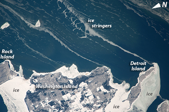 |
| Snow-covered fields appear as geometric patterns on Lake Michigan's Washington Island in this photograph taken by the crew of the International Space Station. The island is 9 km long (5.6 miles) and lies on Lake Michigan's western shore, as a continuation of Wisconsin's Door Peninsula. (Note that north is to the lower left in the image.) White coastal ice hugs the shoreline and connects Washington Island with Detroit Island and Rock Island. Ice typically accumulates first near land, where cooling is more rapid than in deeper lake water. Two other snow-covered islands (image top left) are small enough and far enough from land to evade the collars of ice. On the day this image was taken, southwesterly winds were blowing ice into the lake in the form of long, coherent stringers. The thickness of a stringer is related to the length of coastline that feeds it. The smallest northern stringer (image left) is fed by the shortest section of upwind coastline, and the longest (image right) is supplied by the large amount of shore ice around Detroit Island. These dominant winds keep a narrow zone (along the western shore of the lake) clear of ice, even as accumulations in the winter of 2014 reach the highest levels ever recorded in Lake Michigan. |
| Images: | All Available Images Low-Resolution 275k |
|
| Mission: | ISS038 |
|
| Roll - Frame: | E - 57977 |
|
| Geographical Name: | USA-WISCONSIN |
|
| Features: | WASHINGTON ISLAND, ICE |
|
| Center Lat x Lon: | 45.3N x 86.7W |
|
| Film Exposure: | N=Normal exposure, U=Under exposed, O=Over exposed, F=out of Focus |
|
| Percentage of Cloud Cover-CLDP: | 10 |
|
| Camera:: | N4 |
|
| Camera Tilt: | 33 | LO=Low Oblique, HO=High Oblique, NV=Near Vertical |
| Camera Focal Length: | 1000 |
|
| Nadir to Photo Center Direction: | SE | The direction from the nadir to the center point, N=North, S=South, E=East, W=West |
| Stereo?: | Y=Yes there is an adjacent picture of the same area, N=No there isn't |
|
| Orbit Number: | |
|
| Date: | 20140222 | YYYYMMDD |
| Time: | 195259 | GMT HHMMSS |
| Nadir Lat: | 46.4N |
Latitude of suborbital point of spacecraft |
| Nadir Lon: | 88.8W |
Longitude of suborbital point of spacecraft |
| Sun Azimuth: | 210 | Clockwise angle in degrees from north to the sun measured at the nadir point |
| Space Craft Altitude: | 221 | nautical miles |
| Sun Elevation: | 29 | Angle in degrees between the horizon and the sun, measured at the nadir point |
| Land Views: | ISLAND |
|
| Water Views: | ICE, LAKE |
|
| Atmosphere Views: | |
|
| Man Made Views: | |
|
| City Views: | |
|
Photo is not associated with any sequences | ||
| NASA Home Page |
JSC Home Page |
JSC Digital Image Collection |
Earth Science & Remote Sensing |
|
This service is provided by the International Space Station program and the JSC Earth Science & Remote Sensing Unit, ARES Division, Exploration Integration Science Directorate.

|