Geographic Region: CHILE
Feature: NEVADOS DE CHILLAN,VOLCANO,SNOW,GLACIAL VALLEYS
|
Geographic Region: CHILE Feature: NEVADOS DE CHILLAN,VOLCANO,SNOW,GLACIAL VALLEYS |
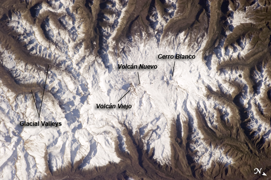 |
| Nevados de Chillan, Chile This astronaut photograph from the International Space Station highlights the Nevados de Chillan, a large volcanic area located near the Chile-Argentina border. Like other historically active volcanoes in the central Andes ranges, the Nevados de Chillan were created by upwelling magma generated by eastward subduction of the dense oceanic crust of the Pacific basin beneath the less dense continental crust of South America. Rising magmas associated with this type of tectonic environment frequently erupt explosively, forming widespread ash and ignimbrite layers. They can also produce less explosive eruptions that form voluminous lava flows - layering together with explosively erupted deposits to build the classic cone-shaped edifice of a stratovolcano over geologic time. The Nevados de Chillan includes three distinct volcanic structures, built within three overlapping calderas that extend along a north-northwest to south-southeast line. The snow-capped volcanic complex sits within the glaciated terrain of the central Andes - glacial valleys are visible at image upper left, upper right, and lower right. The northwestern end of the chain is occupied by the 3212 meter high Cerro Blanco (also known as Volcan Nevado). The 3089 meter-high Volcan Viejo (also known as Volcan Chillan) sits at the southeastern end; this volcano was active during the 17th-19th centuries. A group of lava domes known as Volcan Nuevo formed to the northwest of Volcan Viejo between 1906-1945, followed by an even younger dome complex that formed between 1973-1986 (Volcan Arrau; not indicated on the image). The last reported volcanic activity at Nevados de Chillan took place in 2009 (according to the Smithsonian Institution's Global Volcanism Network). Volcanic activity reports are currently available (in Spanish) from the Servicio Nacional de Geologia y Mineria of Chile. |
| Images: | All Available Images Low-Resolution 249k |
|
| Mission: | ISS036 |
|
| Roll - Frame: | E - 7165 |
|
| Geographical Name: | CHILE |
|
| Features: | NEVADOS DE CHILLAN,VOLCANO,SNOW,GLACIAL VALLEYS |
|
| Center Lat x Lon: | 36.9S x 71.4W |
|
| Film Exposure: | N=Normal exposure, U=Under exposed, O=Over exposed, F=out of Focus |
|
| Percentage of Cloud Cover-CLDP: | 10 |
|
| Camera:: | N5 |
|
| Camera Tilt: | 28 | LO=Low Oblique, HO=High Oblique, NV=Near Vertical |
| Camera Focal Length: | 400 |
|
| Nadir to Photo Center Direction: | SW | The direction from the nadir to the center point, N=North, S=South, E=East, W=West |
| Stereo?: | Y=Yes there is an adjacent picture of the same area, N=No there isn't |
|
| Orbit Number: | |
|
| Date: | 20130611 | YYYYMMDD |
| Time: | 180248 | GMT HHMMSS |
| Nadir Lat: | 35.6S |
Latitude of suborbital point of spacecraft |
| Nadir Lon: | 69.9W |
Longitude of suborbital point of spacecraft |
| Sun Azimuth: | 338 | Clockwise angle in degrees from north to the sun measured at the nadir point |
| Space Craft Altitude: | 227 | nautical miles |
| Sun Elevation: | 28 | Angle in degrees between the horizon and the sun, measured at the nadir point |
| Land Views: | VOLCANO |
|
| Water Views: | |
|
| Atmosphere Views: | |
|
| Man Made Views: | |
|
| City Views: | |
|
Photo is not associated with any sequences | ||
| NASA Home Page |
JSC Home Page |
JSC Digital Image Collection |
Earth Science & Remote Sensing |
|
This service is provided by the International Space Station program and the JSC Earth Science & Remote Sensing Unit, ARES Division, Exploration Integration Science Directorate.

|