
Geographic Region: USA-CALIFORNIA
Feature: SAN DIEGO,TIJUANA,CORONADO,POINT LOMA,PACIFIC OCEAN
|
Geographic Region: USA-CALIFORNIA Feature: SAN DIEGO,TIJUANA,CORONADO,POINT LOMA,PACIFIC OCEAN |
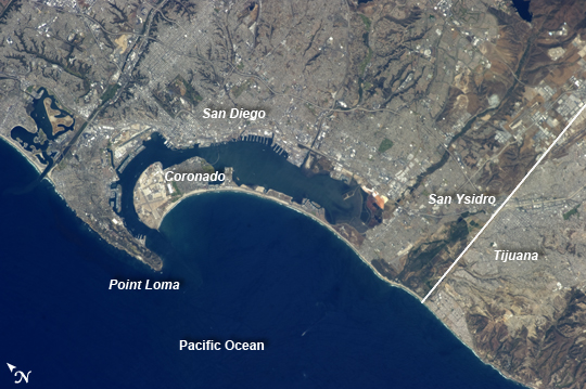 |
| San Diego-Tijuana Region, USA and Mexico The metropolitan areas of San Diego, California, USA; and Tijuana, Baja California, Mexico together form an international conurbation that crosses the USA-Mexico border (white line) at the northern end of the peninsula of Baja California near the city of San Ysidro, CA. This detailed astronaut photograph, taken from the International Space Station, highlights the region. Urban and suburban areas appear a light gray, speckled with white rooftops indicating large industrial and commercial buildings and centers. Vegetated areas - parks, golf courses, and the foothills of nearby mountains - appear green, in contrast to the tan and dark brown of exposed soils and bedrock in highland areas. The city of San Diego was founded in 1769 by Franciscan friar Junipero Serra. While the valley of Tijuana was explored at this time, the city of Tijuana would not be founded until 1889. Today, the San Diego-Tijuana conurbation also includes the cities of Chula Vista, Carlsbad, San Marcos, National City in the USA; and Tecate, and Rosarito Beach in Mexico. The combined population of the region is approximately 5 million according to 2010 census information from both the USA and Mexico. The city of Coronado CA, situated on an artificial peninsula across the bay from San Diego, is both a popular beach resort and the location of US Navy air station and training facilities. Point Loma defines the western boundary of San Diego Bay, and is part of the city of San Diego. While the northern half of the Point Loma peninsula hosts various residential communities, the southern half is federal land occupied by US Navy installations, the Fort Rosecrans National Cemetery and the Cabrillo National Monument that marks the landing of the first European on the west coast of the United States. |
| Images: | All Available Images Low-Resolution 221k |
|
| Mission: | ISS035 |
|
| Roll - Frame: | E - 27265 |
|
| Geographical Name: | USA-CALIFORNIA |
|
| Features: | SAN DIEGO,TIJUANA,CORONADO,POINT LOMA,PACIFIC OCEAN |
|
| Center Lat x Lon: | 32.6N x 117.1W |
|
| Film Exposure: | N=Normal exposure, U=Under exposed, O=Over exposed, F=out of Focus |
|
| Percentage of Cloud Cover-CLDP: | 0 |
|
| Camera:: | N5 |
|
| Camera Tilt: | 12 | LO=Low Oblique, HO=High Oblique, NV=Near Vertical |
| Camera Focal Length: | 400 |
|
| Nadir to Photo Center Direction: | NW | The direction from the nadir to the center point, N=North, S=South, E=East, W=West |
| Stereo?: | Y=Yes there is an adjacent picture of the same area, N=No there isn't |
|
| Orbit Number: | |
|
| Date: | 20130423 | YYYYMMDD |
| Time: | 204741 | GMT HHMMSS |
| Nadir Lat: | 32.2N |
Latitude of suborbital point of spacecraft |
| Nadir Lon: | 116.4W |
Longitude of suborbital point of spacecraft |
| Sun Azimuth: | 221 | Clockwise angle in degrees from north to the sun measured at the nadir point |
| Space Craft Altitude: | 221 | nautical miles |
| Sun Elevation: | 66 | Angle in degrees between the horizon and the sun, measured at the nadir point |
| Land Views: | COAST, PENINSULA |
|
| Water Views: | BAY |
|
| Atmosphere Views: | |
|
| Man Made Views: | |
|
| City Views: | SAN DIEGO |
|
Photo is not associated with any sequences | ||
| NASA Home Page |
JSC Home Page |
JSC Digital Image Collection |
Earth Science & Remote Sensing |
|
This service is provided by the International Space Station program and the JSC Earth Science & Remote Sensing Unit, ARES Division, Exploration Integration Science Directorate.

|