 Photo #: ISS034-E-70070 Date: Jan. 2013
Geographic Region: CHAD
Feature: AORUNGA CRATER,SAND DUNES,SAHARA DESERT
|
Photo #: ISS034-E-70070 Date: Jan. 2013 Geographic Region: CHAD Feature: AORUNGA CRATER,SAND DUNES,SAHARA DESERT |
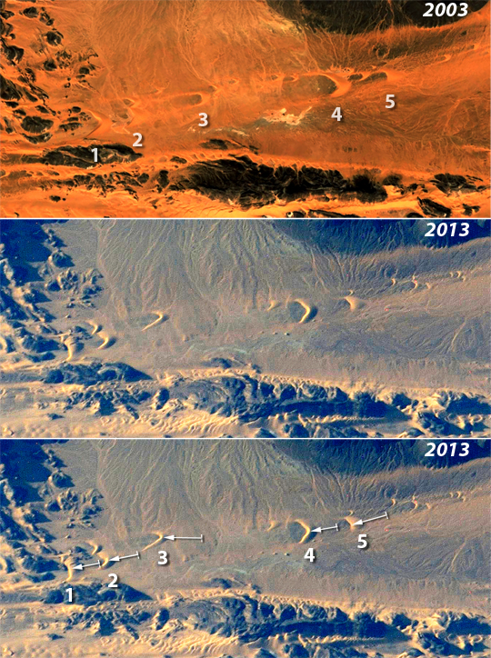 |
| Dune movement, Sahara Desert, Chad, 2003-2013 Note: This caption refers to the image versions labeled "NASA's Earth Observatory web site". Images of the central Sahara Desert taken by crews on the International Space Station (ISS) often include sand dunes. This sequence of images features a series of horn-shaped "barchan" dunes clustered in a narrow corridor between lines of dark-toned hills, the horns pointing in the direction of dune migration, that is, from NNW to SSE, under the influence of the prevailing winds. Thick zones of small, rippled, light-toned dunes can be seen at the bottom of the images, with dry river channels in the center and upper parts. The larger dunes maintain their shape and size well enough to be confidently identified in these images taken nine years apart. The 2003 image was obtained from Google Earth ((c) 2013 CNES/Spot Image, (c) 2013 DigitalGlobe); while the 2013 image was taken by crews on board the ISS. Comparison of the 2003 (top) and 2013 images (center and bottom) shows that five larger dunes appear to have moved, as seen against fixed points such as hills and channels. Measurements show that the dunes have moved hundreds of meters (from left to right: 1: 316m, 2: 275m, 3: 405m, 4: 318m, and 5: 381m). Arrows in the bottom image show the direction and distance of movement. Dunes 3 and 5 have moved furthest--following to the well-known phenomenon that smaller dune size is related to faster movement. The smallest dunes move so fast that they cannot be tracked over a decade, partly because they are absorbed by larger dunes, partly because they move into hilly terrain and break up, and partly because new small dunes are "shed" from the horns of the larger dunes. This is the kind of environmental comparison possible from comparative imagery taken over long time periods. The value of knowledge gained from such comparisons is manyfold. Where large masses of sand move across highways or into farm fields, as is common on the edges of deserts, they cause great environmental damage and cost. It is now possible to predict when dunes are likely to cause such damage so that mitigation efforts can be put in place. |
| Images: | All Available Images Low-Resolution 572k |
|
| Mission: | ISS034 |
|
| Roll - Frame: | E - 70070 |
|
| Geographical Name: | CHAD |
|
| Features: | AORUNGA CRATER,SAND DUNES,SAHARA DESERT |
|
| Center Lat x Lon: | 19.1N x 19.2E |
|
| Film Exposure: | N=Normal exposure, U=Under exposed, O=Over exposed, F=out of Focus |
|
| Percentage of Cloud Cover-CLDP: | 10 |
|
| Camera:: | N4 |
|
| Camera Tilt: | 25 | LO=Low Oblique, HO=High Oblique, NV=Near Vertical |
| Camera Focal Length: | 800 |
|
| Nadir to Photo Center Direction: | NW | The direction from the nadir to the center point, N=North, S=South, E=East, W=West |
| Stereo?: | Y=Yes there is an adjacent picture of the same area, N=No there isn't |
|
| Orbit Number: | |
|
| Date: | 20130106 | YYYYMMDD |
| Time: | 151449 | GMT HHMMSS |
| Nadir Lat: | 18.3N |
Latitude of suborbital point of spacecraft |
| Nadir Lon: | 20.7E |
Longitude of suborbital point of spacecraft |
| Sun Azimuth: | 241 | Clockwise angle in degrees from north to the sun measured at the nadir point |
| Space Craft Altitude: | 216 | nautical miles |
| Sun Elevation: | 12 | Angle in degrees between the horizon and the sun, measured at the nadir point |
| Land Views: | DESERT, DUNE |
|
| Water Views: | |
|
| Atmosphere Views: | |
|
| Man Made Views: | |
|
| City Views: | |
|
Photo is not associated with any sequences | ||
| NASA Home Page |
JSC Home Page |
JSC Digital Image Collection |
Earth Science & Remote Sensing |
|
This service is provided by the International Space Station program and the JSC Earth Science & Remote Sensing Unit, ARES Division, Exploration Integration Science Directorate.

|