 Photo #: ISS034-E-29105 Date: Jan. 2013
Geographic Region: AUSTRALIA-WA
Feature: PICCANINNY IMPACT CRATER, ORD RIVER VALLEY, NICHOLSON R., HILLS, DRAINAGE

 Photo #: ISS034-E-29105 Date: Jan. 2013 Photo #: ISS034-E-29105 Date: Jan. 2013Geographic Region: AUSTRALIA-WA Feature: PICCANINNY IMPACT CRATER, ORD RIVER VALLEY, NICHOLSON R., HILLS, DRAINAGE |
 |
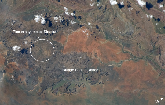
| Piccaninny Impact Structure, Western Australia Note: This caption refers to the image versions labeled "NASA's Earth Observatory web site". The whole world tuned into meteor impacts after the spectacular February 15, 2013 event over Russia's Ural Mountains near Chelyabinsk. The Chelyabinsk meteor exploded while entering the atmosphere, but impact craters document locations where meteors survive transit through the Earth's atmosphere and crash onto the surface. While some meteor impact locations on the Earth's surface are readily recognizable from orbit as distinct circular structures - such as Barringer Crater in Arizona - most are harder to recognize due to erosion, subsequent tectonic alteration of the landscape, or human land use that obscures the feature (such as urban or agricultural development). In cases where only the eroded remnants of a potential impact crater have been recognized, the terms "impact structure" or "astrobleme" are used. Such is the case for the Piccaninny Impact Structure, located in northern Western Australia and featured in this astronaut photograph from the International Space Station (ISS). It is the first confirmed image of the impact structure taken from the ISS. The Piccaninny structure is located within the semi-arid Purnululu National Park and World Heritage site, and is thought to have been formed less than 360 million years ago. Specifically, the 7.5 km diameter structure forms a roughly circular plateau (image left, approximate extent marked by the white ellipse) within the striking sandstone cone towers of the Bungle Bungle Range, visible here as the dark gray-brown regions adjacent to the impact structure. Geological evidence indicating an impact structure includes regional folding and faulting patterns both within and surrounding the plateau. Features confirming an impact, such as shock textures (indicating rapid compression, melting, and fracturing during impact) in rocks and minerals have not yet been found; this is perhaps due to removal during erosion of an original crater. Surface soils of the sparsely vegetated valley adjacent to the Bungle Bungle Range appear a reddish brown at image right. More abundant green vegetation is recognizable in riparian areas along major stream and river channels, such as the Ord River (image right). |
| Images: | All Available Images Low-Resolution 191k |
|
| Mission: | ISS034 |
|
| Roll - Frame: | E - 29105 |
|
| Geographical Name: | AUSTRALIA-WA |
|
| Features: | PICCANINNY IMPACT CRATER, ORD RIVER VALLEY, NICHOLSON R., HILLS, DRAINAGE |
|
| Center Lat x Lon: | 17.4S x 128.4E |
|
| Film Exposure: | N=Normal exposure, U=Under exposed, O=Over exposed, F=out of Focus |
|
| Percentage of Cloud Cover-CLDP: | 25 |
|
| Camera:: | N5 |
|
| Camera Tilt: | 36 | LO=Low Oblique, HO=High Oblique, NV=Near Vertical |
| Camera Focal Length: | 180 |
|
| Nadir to Photo Center Direction: | NW | The direction from the nadir to the center point, N=North, S=South, E=East, W=West |
| Stereo?: | Y=Yes there is an adjacent picture of the same area, N=No there isn't |
|
| Orbit Number: | |
|
| Date: | 20130115 | YYYYMMDD |
| Time: | 063143 | GMT HHMMSS |
| Nadir Lat: | 18.8S |
Latitude of suborbital point of spacecraft |
| Nadir Lon: | 130.7E |
Longitude of suborbital point of spacecraft |
| Sun Azimuth: | 259 | Clockwise angle in degrees from north to the sun measured at the nadir point |
| Space Craft Altitude: | 219 | nautical miles |
| Sun Elevation: | 47 | Angle in degrees between the horizon and the sun, measured at the nadir point |
| Land Views: | CRATER, EROSION, PLATEAU, RANGE, VALLEY |
|
| Water Views: | RIVER |
|
| Atmosphere Views: | |
|
| Man Made Views: | |
|
| City Views: | |
|
Photo is not associated with any sequences | ||
| NASA Home Page |
JSC Home Page |
JSC Digital Image Collection |
Earth Science & Remote Sensing |
|
|