Geographic Region: EGYPT
Feature: PYRAMIDS OF GIZA,KAFR GHATATI,MONSHAAT AL BAKKARI,DESERT
|
Geographic Region: EGYPT Feature: PYRAMIDS OF GIZA,KAFR GHATATI,MONSHAAT AL BAKKARI,DESERT |
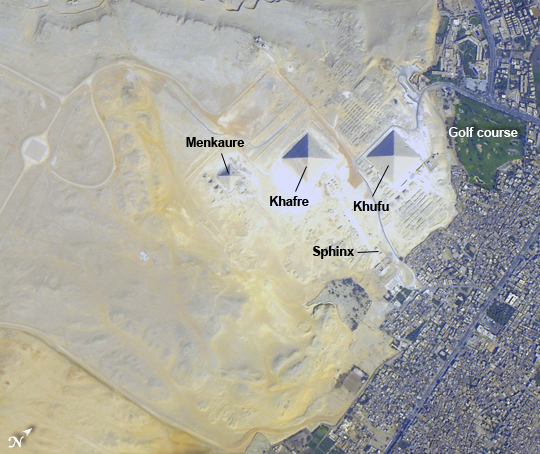 |
| Pyramids at Giza, Egypt Note: This caption refers to the image versions labeled "NASA's Earth Observatory web site". The Great Pyramids at Giza (image center) are the last of the Seven Wonders of the Ancient World, and are perhaps the most famous of the ancient monuments in the Nile River Delta region of Egypt. They are also a favorite subject of photography from orbit - particularly when high resolution imagery can be obtained. This subset of a larger astronaut photograph illustrates the degree of detail visible from the International Space Station using a long focal length lens to provide high magnification of the land surface. With good sun illumination of the scene and a steady hand on the camera to track the feature of interest, current off-the-shelf digital cameras on board the ISS can obtain detailed imagery to rival that of automated satellite sensor systems in orbit. The southeast-facing sides of the pyramids of the pharaohs Khufu, Khafre, and Menkaure are all brightly illuminated by the sun, while the northwest facing sides are in shadow. This shadowing also highlights smaller unfinished pyramids to the south of Menkaure's pyramid, as well as fields of rectangular flat roofed mastabas (tombs) to the east and west of Khufu's pyramid. While not as grand as the pyramids, mastabas were the burial places of prominent persons during the periods of the ancient pharaohs. To the southeast of Khufu's pyramid, the head and rear haunches of the Sphinx are also visible (albeit not clearly). It is a short distance between the glories of ancient Egypt and the modern Cairo metropolitan area to the north and east. The green vegetation of a hotel golf course (image right), and the numerous building and streets of El Giza, provide stark contrast to the bare rock and soil of the adjacent desert. Roadways visible in the desert (image left) connect the urban regions to the east with further development to the north (not shown). |
| Images: | All Available Images Low-Resolution 317k |
|
| Mission: | ISS032 |
|
| Roll - Frame: | E - 9123 |
|
| Geographical Name: | EGYPT |
|
| Features: | PYRAMIDS OF GIZA,KAFR GHATATI,MONSHAAT AL BAKKARI,DESERT |
|
| Center Lat x Lon: | 30.0N x 31.1E |
|
| Film Exposure: | N=Normal exposure, U=Under exposed, O=Over exposed, F=out of Focus |
|
| Percentage of Cloud Cover-CLDP: | 10 |
|
| Camera:: | N4 |
|
| Camera Tilt: | 04 | LO=Low Oblique, HO=High Oblique, NV=Near Vertical |
| Camera Focal Length: | 1200 |
|
| Nadir to Photo Center Direction: | NW | The direction from the nadir to the center point, N=North, S=South, E=East, W=West |
| Stereo?: | Y=Yes there is an adjacent picture of the same area, N=No there isn't |
|
| Orbit Number: | |
|
| Date: | 20120725 | YYYYMMDD |
| Time: | 072145 | GMT HHMMSS |
| Nadir Lat: | 29.8N |
Latitude of suborbital point of spacecraft |
| Nadir Lon: | 31.3E |
Longitude of suborbital point of spacecraft |
| Sun Azimuth: | 96 | Clockwise angle in degrees from north to the sun measured at the nadir point |
| Space Craft Altitude: | 216 | nautical miles |
| Sun Elevation: | 53 | Angle in degrees between the horizon and the sun, measured at the nadir point |
| Land Views: | DESERT |
|
| Water Views: | |
|
| Atmosphere Views: | |
|
| Man Made Views: | PYRAMID |
|
| City Views: | CAIRO |
|
Photo is not associated with any sequences | ||
| NASA Home Page |
JSC Home Page |
JSC Digital Image Collection |
Earth Science & Remote Sensing |
|
This service is provided by the International Space Station program and the JSC Earth Science & Remote Sensing Unit, ARES Division, Exploration Integration Science Directorate.

|