Geographic Region: NAMIBIA
Feature: ETOSHA PAN, W. END, FLOODWATER, LAKES
|
Geographic Region: NAMIBIA Feature: ETOSHA PAN, W. END, FLOODWATER, LAKES |
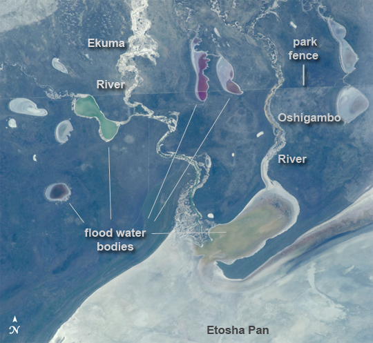 |
| Note: This caption refers to the image versions labeled "NASA's Earth Observatory web site". This astronaut photograph shows the white, salt-covered floor of the northwest corner of the great dry lake in northern Namibia known as the Etosha Pan (lower image margin). Two rivers, the Ekuma and Oshigambo, transport water from the north down to the Etosha Pan proper. In a relatively rare event, water from recent rains has flowed down the larger Ekuma River--in which it appears as a thin blue line within the generally light grey-green floodplain--and fills a lobe of the lake with light green water (lower right quarter of image). Water has also flowed into a small offshoot dry lake where it appears a brighter green (upper left quarter of image). Other smaller lakes at image top center and image left show red and brown water colors. The different colors of lake water are determined by the interplay of water depth and resident organisms such as algae; the algae color varies depending on water temperature and salinity. A similar process is observed in pink and red floodwaters ponded in Lake Eyre, a usually dry lake in Australia's arid center. In this case it is known that the coloration is indeed due to algae growth. Typically, little river water or sediment reaches the floor of the Etosha dry lake because water seeps into the riverbeds along their courses. The floor of the pan itself is seldom seen with even a thin sheet of water. In this image, there was enough surface flow to reach the pan, but too little to flow beyond the inlet bay. A prior flood event, when water entered the pan via the Oshigambo River, was documented in astronaut imagery in 2006. The straight line that crosses the image from upper left to upper right is the northern fence line of Namibia's Etosha National Park. This straight, 3 meter-high fence keeps wildlife from crossing into the numerous small farms of the relatively densely populated Owambo region of Namibia, north of the pan. The large Etosha dry lakebed (120 km or 75 mi long) is the center of Namibia's largest wildlife park, a major tourist attraction. |
| Images: | All Available Images Low-Resolution 260k |
|
| Mission: | ISS030 |
|
| Roll - Frame: | E - 234965 |
|
| Geographical Name: | NAMIBIA |
|
| Features: | ETOSHA PAN, W. END, FLOODWATER, LAKES |
|
| Center Lat x Lon: | 18.5S x 16.0E |
|
| Film Exposure: | N=Normal exposure, U=Under exposed, O=Over exposed, F=out of Focus |
|
| Percentage of Cloud Cover-CLDP: | 10 |
|
| Camera:: | N2 |
|
| Camera Tilt: | 25 | LO=Low Oblique, HO=High Oblique, NV=Near Vertical |
| Camera Focal Length: | 180 |
|
| Nadir to Photo Center Direction: | SE | The direction from the nadir to the center point, N=North, S=South, E=East, W=West |
| Stereo?: | Y=Yes there is an adjacent picture of the same area, N=No there isn't |
|
| Orbit Number: | |
|
| Date: | 20111230 | YYYYMMDD |
| Time: | 082641 | GMT HHMMSS |
| Nadir Lat: | 17.1S |
Latitude of suborbital point of spacecraft |
| Nadir Lon: | 15.0E |
Longitude of suborbital point of spacecraft |
| Sun Azimuth: | 106 | Clockwise angle in degrees from north to the sun measured at the nadir point |
| Space Craft Altitude: | 216 | nautical miles |
| Sun Elevation: | 53 | Angle in degrees between the horizon and the sun, measured at the nadir point |
| Land Views: | |
|
| Water Views: | BAY, INLET, LAKE, RIVER, SEDIMENT |
|
| Atmosphere Views: | |
|
| Man Made Views: | |
|
| City Views: | |
|
Photo is not associated with any sequences | ||
| NASA Home Page |
JSC Home Page |
JSC Digital Image Collection |
Earth Science & Remote Sensing |
|
This service is provided by the International Space Station program and the JSC Earth Science & Remote Sensing Unit, ARES Division, Exploration Integration Science Directorate.

|