Geographic Region: MADAGASCAR
Feature: BETSIBOKA RIVER, MAHAJAMBE BAY,MAHAJANGA,MOZAMBIQUE CHANNEL
|
Geographic Region: MADAGASCAR Feature: BETSIBOKA RIVER, MAHAJAMBE BAY,MAHAJANGA,MOZAMBIQUE CHANNEL |
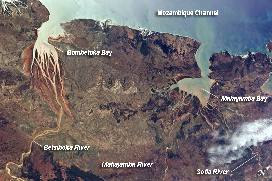 |
| Estuaries, Northwestern Coast of Madagascar Regions where fresh water flowing in rivers and salt water from the seas and oceans mix are called estuaries, and they are among the most biologically productive ecosystems on Earth. This astronaut photograph, taken from the International Space Station, highlights two estuaries located along the northwestern coastline of the island of Madagascar. The Mozambique Channel (image top) separates Madagascar from the southeastern coast of Africa. Bombetoka Bay (image upper left) is fed by the Betsiboka River and is a frequent subject of astronaut photography due to its striking red floodplain sediments. Mahajamba Bay (image right) is fed by several rivers including the Mahajamba and Sofia Rivers; like the Betsiboka, the floodplains of these rivers also contain reddish sediments eroded from their basins upstream. The brackish (mix of fresh and salty water) conditions found in most estuaries host unique plant and animal species adapted to live in such environments. Mangroves in particular are a common plant species found in and around Madagascar estuaries, and Bombetoka Bay contains some of the largest remaining stands. Estuaries also host abundant fish and shellfish species - many of which need access to freshwater for a portion of their life cycles - and these in turn support local and migratory bird species that prey on them. However, human activities such as urban development, overfishing, and increased sediment loading from erosion of upriver highlands threaten the ecosystem health of the estuaries. In particular, the silt deposits in Bombetoka Bay at the mouth of the Betsiboka River have been filling in the bay. |
| Images: | All Available Images Low-Resolution 275k |
|
| Mission: | ISS028 |
|
| Roll - Frame: | E - 6687 |
|
| Geographical Name: | MADAGASCAR |
|
| Features: | BETSIBOKA RIVER, MAHAJAMBE BAY,MAHAJANGA,MOZAMBIQUE CHANNEL |
|
| Center Lat x Lon: | 15.5S x 47.0E |
|
| Film Exposure: | N=Normal exposure, U=Under exposed, O=Over exposed, F=out of Focus |
|
| Percentage of Cloud Cover-CLDP: | 10 |
|
| Camera:: | N2 |
|
| Camera Tilt: | 36 | LO=Low Oblique, HO=High Oblique, NV=Near Vertical |
| Camera Focal Length: | 70 |
|
| Nadir to Photo Center Direction: | NE | The direction from the nadir to the center point, N=North, S=South, E=East, W=West |
| Stereo?: | Y=Yes there is an adjacent picture of the same area, N=No there isn't |
|
| Orbit Number: | 3857 |
|
| Date: | 20110602 | YYYYMMDD |
| Time: | 085845 | GMT HHMMSS |
| Nadir Lat: | 17.2S |
Latitude of suborbital point of spacecraft |
| Nadir Lon: | 45.5E |
Longitude of suborbital point of spacecraft |
| Sun Azimuth: | 359 | Clockwise angle in degrees from north to the sun measured at the nadir point |
| Space Craft Altitude: | 188 | nautical miles |
| Sun Elevation: | 51 | Angle in degrees between the horizon and the sun, measured at the nadir point |
| Land Views: | COAST, EROSION, ISLAND |
|
| Water Views: | BAY, CHANNEL, RIVER, SEDIMENT |
|
| Atmosphere Views: | |
|
| Man Made Views: | |
|
| City Views: | |
|
Photo is not associated with any sequences | ||
| NASA Home Page |
JSC Home Page |
JSC Digital Image Collection |
Earth Science & Remote Sensing |
|
This service is provided by the International Space Station program and the JSC Earth Science & Remote Sensing Unit, ARES Division, Exploration Integration Science Directorate.

|