Geographic Region: AUSTRALIA-WA
Feature: SHOEMAKER IMPACT CRATER,LAKE NABBERU,CLOUD SHADOWS
|
Geographic Region: AUSTRALIA-WA Feature: SHOEMAKER IMPACT CRATER,LAKE NABBERU,CLOUD SHADOWS |
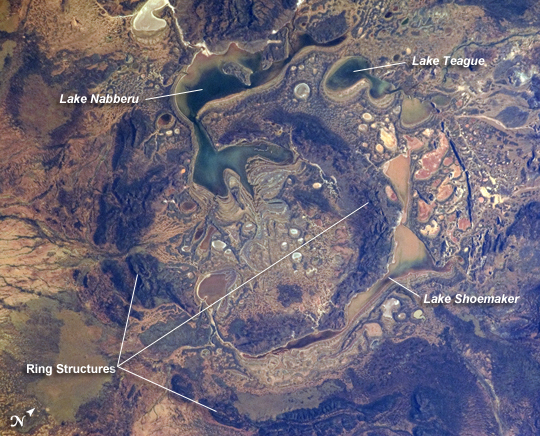 |
| Shoemaker Impact Structure, Western Australia The Shoemaker (formerly Teague) Impact Structure--located in Western Australia to the southeast of the Carnarvon Range--presents an other-worldly appearance in this astronaut photograph. The Shoemaker impact site is approximately 30 km in diameter, and is clearly defined by concentric ring structures formed in sedimentary rocks (brown to dark brown, image center) that were deformed by the impact event approximately 1630 million years ago (as reported by the Earth Impact Database). Other published age-dating analyses of granitic rocks at the core of the structure call into question this age of the impact event (Pirajno et al. 2003). Several saline and ephemeral lakes--Nabberu, Teague, Shoemaker, and numerous smaller ponds--occupy the land surface between the concentric ring structures. Differences in color result from both water depth and suspended sediments, with some bright salt crusts visible around the edges of smaller ponds (image center). The Teague Impact Structure was renamed Shoemaker in honor of Dr. Eugene M. Shoemaker (1928-1997), a pioneer in the field of impact crater studies and planetary geology, and founder of the Astrogeology Branch of the United States Geological Survey. Reference: Pirajno F, P Hawke, AY Glikson, PW Haines, and T Uysal (2003). Shoemaker impact structure, Western Australia. Australian Journal of Earth Sciences 50:775-796. |
| Images: | All Available Images Low-Resolution 351k |
|
| Mission: | ISS028 |
|
| Roll - Frame: | E - 14782 |
|
| Geographical Name: | AUSTRALIA-WA |
|
| Features: | SHOEMAKER IMPACT CRATER,LAKE NABBERU,CLOUD SHADOWS |
|
| Center Lat x Lon: | 25.8S x 121.0E |
|
| Film Exposure: | N=Normal exposure, U=Under exposed, O=Over exposed, F=out of Focus |
|
| Percentage of Cloud Cover-CLDP: | 10 |
|
| Camera:: | N2 |
|
| Camera Tilt: | 24 | LO=Low Oblique, HO=High Oblique, NV=Near Vertical |
| Camera Focal Length: | 200 |
|
| Nadir to Photo Center Direction: | E | The direction from the nadir to the center point, N=North, S=South, E=East, W=West |
| Stereo?: | Y=Yes there is an adjacent picture of the same area, N=No there isn't |
|
| Orbit Number: | 399 |
|
| Date: | 20110706 | YYYYMMDD |
| Time: | 233635 | GMT HHMMSS |
| Nadir Lat: | 26.2S |
Latitude of suborbital point of spacecraft |
| Nadir Lon: | 119.5E |
Longitude of suborbital point of spacecraft |
| Sun Azimuth: | 60 | Clockwise angle in degrees from north to the sun measured at the nadir point |
| Space Craft Altitude: | 208 | nautical miles |
| Sun Elevation: | 9 | Angle in degrees between the horizon and the sun, measured at the nadir point |
| Land Views: | BASIN, CRATER |
|
| Water Views: | |
|
| Atmosphere Views: | |
|
| Man Made Views: | |
|
| City Views: | |
|
Photo is not associated with any sequences | ||
| NASA Home Page |
JSC Home Page |
JSC Digital Image Collection |
Earth Science & Remote Sensing |
|
This service is provided by the International Space Station program and the JSC Earth Science & Remote Sensing Unit, ARES Division, Exploration Integration Science Directorate.

|