Geographic Region: OMAN
Feature: RUB AL KHALI, LINEAR DUNES, STAR DUNES,SALT FLATS
|
Geographic Region: OMAN Feature: RUB AL KHALI, LINEAR DUNES, STAR DUNES,SALT FLATS |
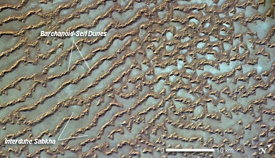 |
| Ar Rub' al Khali Sand Sea, Arabian Peninsula The Ar Rub' al Khali, also known as the "Empty Quarter", is a large region of sand dunes and interdune flats known as a sand sea (or erg). This astronaut photograph highlights a part of the Ar Rub' al Khali located close to its southeastern margin in the Sultanate of Oman. Reddish-brown, large linear sand dunes alternate with blue-gray interdune salt flats known as sabkhas at image left. The major trend of the linear dunes is transverse to northwesterly trade winds that originate in Iraq (known as the Shamal winds). Formation of secondary barchan (crescent-shaped) and star dunes (dune crests in several directions originating from a single point, looking somewhat like a starfish from above) on the linear dunes is supported by southwesterly winds that occur during the monsoon season (Kharif winds). The long linear dunes begin to break up into isolated large star dunes to the northeast and east (image right). This is likely a result of both wind pattern interactions and changes in the sand supply to the dunes. The Empty Quarter covers much of the south-central portion of the Arabian Peninsula, and with an area of approximately 660,000 km2 it is the largest continuous sand desert on Earth. The Empty Quarter is so called as the dominantly hyperarid climate and difficulty of travel through the dunes has not encouraged permanent settlement within the region. There is geological and archeological evidence to support cooler and wetter past climates in the region together with human settlement. This evidence includes exposed lakebed sediments, scattered stone tools, and the fossils of hippopotamus, water buffalo, and long-horned cattle. |
| Images: | All Available Images Low-Resolution 260k |
|
| Mission: | ISS027 |
|
| Roll - Frame: | E - 34290 |
|
| Geographical Name: | OMAN |
|
| Features: | RUB AL KHALI, LINEAR DUNES, STAR DUNES,SALT FLATS |
|
| Center Lat x Lon: | 19.1N x 53.2E |
|
| Film Exposure: | N=Normal exposure, U=Under exposed, O=Over exposed, F=out of Focus |
|
| Percentage of Cloud Cover-CLDP: | 10 |
|
| Camera:: | N5 |
|
| Camera Tilt: | 13 | LO=Low Oblique, HO=High Oblique, NV=Near Vertical |
| Camera Focal Length: | 200 |
|
| Nadir to Photo Center Direction: | NW | The direction from the nadir to the center point, N=North, S=South, E=East, W=West |
| Stereo?: | Y=Yes there is an adjacent picture of the same area, N=No there isn't |
|
| Orbit Number: | 3592 |
|
| Date: | 20110516 | YYYYMMDD |
| Time: | 132127 | GMT HHMMSS |
| Nadir Lat: | 18.5N |
Latitude of suborbital point of spacecraft |
| Nadir Lon: | 53.6E |
Longitude of suborbital point of spacecraft |
| Sun Azimuth: | 284 | Clockwise angle in degrees from north to the sun measured at the nadir point |
| Space Craft Altitude: | 186 | nautical miles |
| Sun Elevation: | 20 | Angle in degrees between the horizon and the sun, measured at the nadir point |
| Land Views: | DESERT, DUNE |
|
| Water Views: | |
|
| Atmosphere Views: | |
|
| Man Made Views: | |
|
| City Views: | |
|
Photo is not associated with any sequences | ||
| NASA Home Page |
JSC Home Page |
JSC Digital Image Collection |
Earth Science & Remote Sensing |
|
This service is provided by the International Space Station program and the JSC Earth Science & Remote Sensing Unit, ARES Division, Exploration Integration Science Directorate.

|