Geographic Region: BRAZIL
Feature: ROW AGRICULTURE, CENTER PIVOT AGRICULTURE,FALLOW FIELDS
|
Geographic Region: BRAZIL Feature: ROW AGRICULTURE, CENTER PIVOT AGRICULTURE,FALLOW FIELDS |
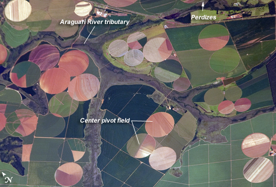 |
| Agricultural Fields near Perdizes, Minas Gerais, Brazil This detailed astronaut photograph illustrates diverse agricultural landscape patterns in the western part of the Brazilian State of Minas Gerais. Perhaps most widely known for its mineral wealth, Minas Gerais is also a large agricultural producer in Brazil. The fields in the image are located to the southwest of the city of Perdizes, which means "partridges" in Portuguese. A mix of regularly-gridded polygonal fields, and circular center-pivot fields, marks the human land use of the region. Small tributary streams (and their adjacent floodplains) of the Araguari River extend like fingers throughout the agricultural landscape. The visual diversity of field forms is matched by the variety of crops produced here: sunflowers, wheat, potatoes, coffee, rice, soybeans, and corn are among the agricultural products of the region. While the Northern Hemisphere is still in the grip of winter, crops are growing in the Southern Hemisphere as indicated by the many green fields in the image. Fallow fields--fields not in active agricultural use--display the violet, reddish to light tan soils common to this part of Brazil. The darker soils are often rich in iron and aluminum oxides, and are typical of highly weathered soil material that forms in hot, humid climates. |
| Images: | All Available Images Low-Resolution 244k |
|
| Mission: | ISS026 |
|
| Roll - Frame: | E - 25373 |
|
| Geographical Name: | BRAZIL |
|
| Features: | ROW AGRICULTURE, CENTER PIVOT AGRICULTURE,FALLOW FIELDS |
|
| Center Lat x Lon: | 19.4S x 47.4W |
|
| Film Exposure: | N=Normal exposure, U=Under exposed, O=Over exposed, F=out of Focus |
|
| Percentage of Cloud Cover-CLDP: | 10 |
|
| Camera:: | N2 |
|
| Camera Tilt: | 34 | LO=Low Oblique, HO=High Oblique, NV=Near Vertical |
| Camera Focal Length: | 800 |
|
| Nadir to Photo Center Direction: | SW | The direction from the nadir to the center point, N=North, S=South, E=East, W=West |
| Stereo?: | Y=Yes there is an adjacent picture of the same area, N=No there isn't |
|
| Orbit Number: | 2096 |
|
| Date: | 20110210 | YYYYMMDD |
| Time: | 124344 | GMT HHMMSS |
| Nadir Lat: | 17.5S |
Latitude of suborbital point of spacecraft |
| Nadir Lon: | 46.4W |
Longitude of suborbital point of spacecraft |
| Sun Azimuth: | 91 | Clockwise angle in degrees from north to the sun measured at the nadir point |
| Space Craft Altitude: | 192 | nautical miles |
| Sun Elevation: | 52 | Angle in degrees between the horizon and the sun, measured at the nadir point |
| Land Views: | |
|
| Water Views: | RIVER |
|
| Atmosphere Views: | |
|
| Man Made Views: | |
|
| City Views: | |
|
Photo is not associated with any sequences | ||
| NASA Home Page |
JSC Home Page |
JSC Digital Image Collection |
Earth Science & Remote Sensing |
|
This service is provided by the International Space Station program and the JSC Earth Science & Remote Sensing Unit, ARES Division, Exploration Integration Science Directorate.

|