Geographic Region: RUSSIAN FEDERATION
Feature: ONEKOTAN ISLAND,TAO-RUSYR CALDERA,NEMO PEAK,SNOW
|
Geographic Region: RUSSIAN FEDERATION Feature: ONEKOTAN ISLAND,TAO-RUSYR CALDERA,NEMO PEAK,SNOW |
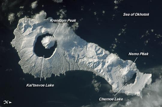 |
| Onekotan Island, Kuril Islands, Russian Federation Snow cover highlights the calderas and volcanic cones that form the northern and southern ends of Onekotan Island, part of the Russian Federation in the western Pacific Ocean. Calderas are depressions formed when a volcano empties its magma chamber in an explosive eruption and then the overlaying material collapses into the evacuated space. In this astronaut photograph from the International Space Station, the northern end of the island (image right) is dominated by the Nemo Peak volcano, which began forming within an older caldera approximately 9,500 years ago. The last recorded eruption at Nemo Peak occurred in the early 18th century. The southern end of the island was formed by the 7.5 kilometer (4.6 mile) wide Tao-Rusyr Caldera. The caldera is filled by Kal'tsevoe Lake and Krenitzyn Peak, a volcano that has only erupted once in recorded history (in 1952). Extending between northeastern Japan and the Kamchatka Peninsula of Russian, the Kurils are an island arc located along the Pacific "Ring of Fire." Island arcs form along an active boundary between two tectonic plates, where one plate is being driven beneath the other (subduction). Magma generated by the subduction process feeds volcanoes--which eventually form volcanic islands over the subduction boundary. |
| Images: | All Available Images Low-Resolution 164k |
|
| Mission: | ISS026 |
|
| Roll - Frame: | E - 16287 |
|
| Geographical Name: | RUSSIAN FEDERATION |
|
| Features: | ONEKOTAN ISLAND,TAO-RUSYR CALDERA,NEMO PEAK,SNOW |
|
| Center Lat x Lon: | 49.4N x 154.8E |
|
| Film Exposure: | N=Normal exposure, U=Under exposed, O=Over exposed, F=out of Focus |
|
| Percentage of Cloud Cover-CLDP: | 10 |
|
| Camera:: | N2 |
|
| Camera Tilt: | 30 | LO=Low Oblique, HO=High Oblique, NV=Near Vertical |
| Camera Focal Length: | 180 |
|
| Nadir to Photo Center Direction: | NE | The direction from the nadir to the center point, N=North, S=South, E=East, W=West |
| Stereo?: | Y=Yes there is an adjacent picture of the same area, N=No there isn't |
|
| Orbit Number: | 1587 |
|
| Date: | 20110109 | YYYYMMDD |
| Time: | 034327 | GMT HHMMSS |
| Nadir Lat: | 48.2N |
Latitude of suborbital point of spacecraft |
| Nadir Lon: | 153.5E |
Longitude of suborbital point of spacecraft |
| Sun Azimuth: | 207 | Clockwise angle in degrees from north to the sun measured at the nadir point |
| Space Craft Altitude: | 185 | nautical miles |
| Sun Elevation: | 16 | Angle in degrees between the horizon and the sun, measured at the nadir point |
| Land Views: | CALDERA, ISLAND, VOLCANO |
|
| Water Views: | LAKE, OCEAN |
|
| Atmosphere Views: | |
|
| Man Made Views: | |
|
| City Views: | |
|
Photo is not associated with any sequences | ||
| NASA Home Page |
JSC Home Page |
JSC Digital Image Collection |
Earth Science & Remote Sensing |
|
This service is provided by the International Space Station program and the JSC Earth Science & Remote Sensing Unit, ARES Division, Exploration Integration Science Directorate.

|