Geographic Region: NEPAL
Feature: KATHMANDU, AIRPORT, FOREST, MTS.
|
Geographic Region: NEPAL Feature: KATHMANDU, AIRPORT, FOREST, MTS. |
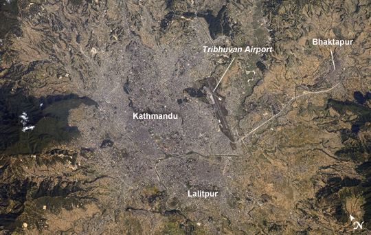 |
| Kathmandu, Nepal The capital and largest city of Nepal, Kathmandu, occupies much of the valley located near the center of the country. Nepal is home to much of the Himalaya mountain range between Tibet (China) to the north and India to the south. Geological and fossil evidence indicates that the Kathmandu Valley was covered by a large lake between approximately 2.8 million and 10,000 years ago. Paleo-Kathmandu Lake is thought to have drained in phases due to the drying of the regional climate; continuing mountain building--tectonic uplift and faulting--in the region; and the formation of an integrated drainage system, as river channels cut through previous rock ridge dams. The green, vegetated slopes that ring the Kathmandu metro area (light gray, image center) include both forest reserves and national parks. The metropolitan area is relatively flat compared to the surrounding mountains. Tribhuvan International Airport, near the eastern margin of the city, is the only international airport in Nepal. Archeological evidence suggests that the human development of Kathmandu, together with the nearby "sister cities" of Lalitpur and Bhaktapur, began almost 2,000 years ago. Today, Kathmandu and its sister cities form the governmental, cultural, and--as a main access point to the Himalayas for tourism--economic center of the country. |
| Images: | All Available Images Low-Resolution 273k |
|
| Mission: | ISS025 |
|
| Roll - Frame: | E - 13115 |
|
| Geographical Name: | NEPAL |
|
| Features: | KATHMANDU, AIRPORT, FOREST, MTS. |
|
| Center Lat x Lon: | 27.7N x 85.3E |
|
| Film Exposure: | N=Normal exposure, U=Under exposed, O=Over exposed, F=out of Focus |
|
| Percentage of Cloud Cover-CLDP: | 10 |
|
| Camera:: | N2 |
|
| Camera Tilt: | 37 | LO=Low Oblique, HO=High Oblique, NV=Near Vertical |
| Camera Focal Length: | 400 |
|
| Nadir to Photo Center Direction: | E | The direction from the nadir to the center point, N=North, S=South, E=East, W=West |
| Stereo?: | Y=Yes there is an adjacent picture of the same area, N=No there isn't |
|
| Orbit Number: | 629 |
|
| Date: | 20101109 | YYYYMMDD |
| Time: | 064109 | GMT HHMMSS |
| Nadir Lat: | 26.9N |
Latitude of suborbital point of spacecraft |
| Nadir Lon: | 83.1E |
Longitude of suborbital point of spacecraft |
| Sun Azimuth: | 190 | Clockwise angle in degrees from north to the sun measured at the nadir point |
| Space Craft Altitude: | 190 | nautical miles |
| Sun Elevation: | 46 | Angle in degrees between the horizon and the sun, measured at the nadir point |
| Land Views: | FOREST, MOUNTAIN, RANGE, VALLEY |
|
| Water Views: | |
|
| Atmosphere Views: | |
|
| Man Made Views: | AIRPORT |
|
| City Views: | KATHMANDU |
|
Photo is not associated with any sequences | ||
| NASA Home Page |
JSC Home Page |
JSC Digital Image Collection |
Earth Science & Remote Sensing |
|
This service is provided by the International Space Station program and the JSC Earth Science & Remote Sensing Unit, ARES Division, Exploration Integration Science Directorate.

|