
Geographic Region: USA-UTAH
Feature: TWITCHELL CANYON FIRE, SMOKE PLUMES,TUSHAR MOUNTAINS
|
Geographic Region: USA-UTAH Feature: TWITCHELL CANYON FIRE, SMOKE PLUMES,TUSHAR MOUNTAINS |
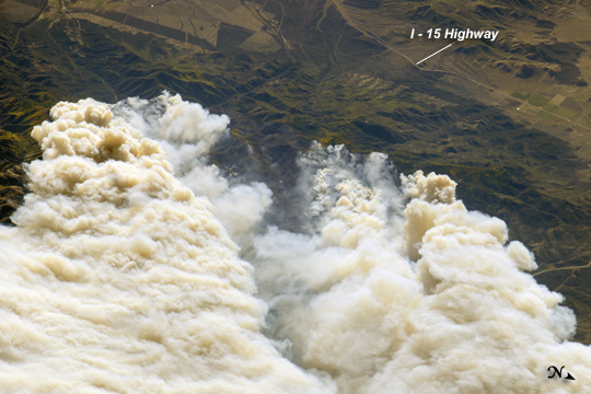 |
| Twitchell Canyon Fire, Central Utah The Twitchell Canyon Fire, near central Utah's Fishlake National Forest, was reported to cover approximately 13,383 hectares (134 square kilometers, or 33,071 acres) as of September 21, 2010. The crew on the International Space Station (ISS) took this photograph of the smoke plumes generated by fires close to the southwestern edge of the burned area. The fire was started by a lightning strike on July 20, 2010. The photograph is highly oblique; that is, it was taken at an angle rather than looking straight down towards the Earth's surface (a nadir view). The ISS was located over a point approximately 509 kilometers (316 miles) to the northeast, near the Colorado/Wyoming border, at the time. Southwesterly winds stretched smoke plumes to the northeast. While the Twitchell Canyon region is sparsely populated, Interstate Highway 15 is visible at the upper right. A MODIS image acquired a day earlier than the astronaut photograph provides a regional view of the fire. |
| Images: | All Available Images Low-Resolution 224k |
|
| Mission: | ISS024 |
|
| Roll - Frame: | E - 15121 |
|
| Geographical Name: | USA-UTAH |
|
| Features: | TWITCHELL CANYON FIRE, SMOKE PLUMES,TUSHAR MOUNTAINS |
|
| Center Lat x Lon: | 38.4N x 112.5W |
|
| Film Exposure: | N=Normal exposure, U=Under exposed, O=Over exposed, F=out of Focus |
|
| Percentage of Cloud Cover-CLDP: | 10 |
|
| Camera:: | N4 |
|
| Camera Tilt: | HO | LO=Low Oblique, HO=High Oblique, NV=Near Vertical |
| Camera Focal Length: | 1000 |
|
| Nadir to Photo Center Direction: | W | The direction from the nadir to the center point, N=North, S=South, E=East, W=West |
| Stereo?: | Y=Yes there is an adjacent picture of the same area, N=No there isn't |
|
| Orbit Number: | 3853 |
|
| Date: | 20100920 | YYYYMMDD |
| Time: | 230148 | GMT HHMMSS |
| Nadir Lat: | 40.5N |
Latitude of suborbital point of spacecraft |
| Nadir Lon: | 106.8W |
Longitude of suborbital point of spacecraft |
| Sun Azimuth: | 250 | Clockwise angle in degrees from north to the sun measured at the nadir point |
| Space Craft Altitude: | 190 | nautical miles |
| Sun Elevation: | 23 | Angle in degrees between the horizon and the sun, measured at the nadir point |
| Land Views: | FOREST |
|
| Water Views: | |
|
| Atmosphere Views: | SMOKE |
|
| Man Made Views: | HIGHWAY |
|
| City Views: | |
|
Photo is not associated with any sequences | ||
| NASA Home Page |
JSC Home Page |
JSC Digital Image Collection |
Earth Science & Remote Sensing |
|
This service is provided by the International Space Station program and the JSC Earth Science & Remote Sensing Unit, ARES Division, Exploration Integration Science Directorate.

|