Geographic Region: COLOMBIA
Feature: NEVADO DEL RUIZ VOLCANO, GLACIERS, LAVA FLOWS
|
Geographic Region: COLOMBIA Feature: NEVADO DEL RUIZ VOLCANO, GLACIERS, LAVA FLOWS |
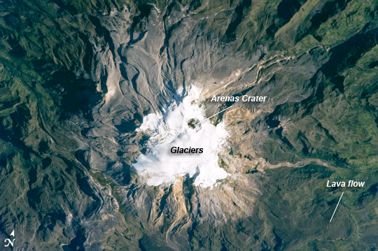 |
| Nevado del Ruiz Volcano, Colombia Nevado del Ruiz Volcano (image center) is located approximately 140 kilometers (87 miles) to the northwest of Colombia's capital, Bogota. Covering over 200 square kilometers (77 square miles), Nevado del Ruiz is a large stratovolcano--a cone-shaped volcano built from successive layers of lava, ash, and pyroclastic flow deposits. The volcano is fed by magma generated above the boundary between the subducting Nazca and overriding South American tectonic plates. The historical record of eruptions at the volcano extends back to 1570, but the most damaging eruption in recent times took place in 1985. On the November 13, 1985, an explosive eruption at the Arenas Crater (image center) melted ice and snow at the summit of the volcano. Mudflows (lahars) swept tens of kilometers down river valleys along the volcano's flanks, killing at least 23,000 people. Most of the fatalities occurred in the town of Armero which was completely inundated by lahars. Eruptive activity at Nevado del Ruiz may have occurred in 1994, but this is not confirmed. The volcano's summit and upper flanks are covered by several glaciers that appear as a white mass surrounding the 1-kilometer- (0.6-mile-) wide Arenas Crater; meltwater from these glaciers has incised the gray to tan ash and pyroclastic flow deposits mantling the lower slopes. A well-defined lava flow is visible at image lower right. This astronaut photograph was taken at approximately 7:45 a.m. local time, when the Sun was still fairly low above the horizon, leading to shadowing to the west of topographic high points. |
| Images: | All Available Images Low-Resolution 293k |
|
| Mission: | ISS023 |
|
| Roll - Frame: | E - 27737 |
|
| Geographical Name: | COLOMBIA |
|
| Features: | NEVADO DEL RUIZ VOLCANO, GLACIERS, LAVA FLOWS |
|
| Center Lat x Lon: | 4.9N x 75.3W |
|
| Film Exposure: | N=Normal exposure, U=Under exposed, O=Over exposed, F=out of Focus |
|
| Percentage of Cloud Cover-CLDP: | 10 |
|
| Camera:: | N5 |
|
| Camera Tilt: | 13 | LO=Low Oblique, HO=High Oblique, NV=Near Vertical |
| Camera Focal Length: | 800 |
|
| Nadir to Photo Center Direction: | N | The direction from the nadir to the center point, N=North, S=South, E=East, W=West |
| Stereo?: | Y=Yes there is an adjacent picture of the same area, N=No there isn't |
|
| Orbit Number: | 1486 |
|
| Date: | 20100423 | YYYYMMDD |
| Time: | 124537 | GMT HHMMSS |
| Nadir Lat: | 4.2N |
Latitude of suborbital point of spacecraft |
| Nadir Lon: | 75.1W |
Longitude of suborbital point of spacecraft |
| Sun Azimuth: | 78 | Clockwise angle in degrees from north to the sun measured at the nadir point |
| Space Craft Altitude: | 185 | nautical miles |
| Sun Elevation: | 27 | Angle in degrees between the horizon and the sun, measured at the nadir point |
| Land Views: | CRATER, VOLCANO |
|
| Water Views: | |
|
| Atmosphere Views: | |
|
| Man Made Views: | |
|
| City Views: | |
|
Photo is not associated with any sequences | ||
| NASA Home Page |
JSC Home Page |
JSC Digital Image Collection |
Earth Science & Remote Sensing |
|
This service is provided by the International Space Station program and the JSC Earth Science & Remote Sensing Unit, ARES Division, Exploration Integration Science Directorate.

|