Geographic Region: ITALY
Feature: CALABRIA, CLOUDS, TYRRHENIAN SEA,IONIAN SEA,SUNGLINT
|
Geographic Region: ITALY Feature: CALABRIA, CLOUDS, TYRRHENIAN SEA,IONIAN SEA,SUNGLINT |
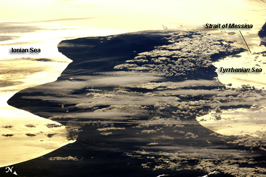 |
| Cloud Formations and Sunglint, Italy This astronaut photograph shows the Calabria region of southern Italy--the toe of Italy's "boot"--outlined by the Ionian and Tyrrhenian Seas to the southeast and northwest respectively. The water surfaces present a mirror-like appearance due to sunglint. This phenomenon is caused by sunlight reflecting off the water surface directly back towards the astronaut observer on board the International Space Station (ISS). The ISS was located over northwestern Romania, approximately 1,040 kilometers to the northeast of Calabria, when this image was taken. The Calabrian Peninsula appears shortened and distorted due to the extreme sideways viewing angle from the ISS. Such a perspective is termed oblique, as opposed to a nadir view, in which the astronaut is looking directly downwards towards the Earth's surface from the ISS. This highly oblique view also highlights two distinct cloud patterns over the Calabrian interior. Patchy, highly textured cumulus clouds are present at lower altitudes, while grey altostratus clouds are stretched out by prevailing winds at higher altitudes. The Strait of Messina, just visible at image upper right, marks the boundary between the coastline of Italy and the island of Sicily. |
| Images: | All Available Images Low-Resolution 223k |
|
| Mission: | ISS022 |
|
| Roll - Frame: | E - 5807 |
|
| Geographical Name: | ITALY |
|
| Features: | CALABRIA, CLOUDS, TYRRHENIAN SEA,IONIAN SEA,SUNGLINT |
|
| Center Lat x Lon: | 38.5N x 16.1E |
|
| Film Exposure: | N=Normal exposure, U=Under exposed, O=Over exposed, F=out of Focus |
|
| Percentage of Cloud Cover-CLDP: | 50 |
|
| Camera:: | N2 |
|
| Camera Tilt: | HO | LO=Low Oblique, HO=High Oblique, NV=Near Vertical |
| Camera Focal Length: | 400 |
|
| Nadir to Photo Center Direction: | SW | The direction from the nadir to the center point, N=North, S=South, E=East, W=West |
| Stereo?: | Y=Yes there is an adjacent picture of the same area, N=No there isn't |
|
| Orbit Number: | 3263 |
|
| Date: | 20091203 | YYYYMMDD |
| Time: | 122243 | GMT HHMMSS |
| Nadir Lat: | 46.6N |
Latitude of suborbital point of spacecraft |
| Nadir Lon: | 22.3E |
Longitude of suborbital point of spacecraft |
| Sun Azimuth: | 209 | Clockwise angle in degrees from north to the sun measured at the nadir point |
| Space Craft Altitude: | 180 | nautical miles |
| Sun Elevation: | 16 | Angle in degrees between the horizon and the sun, measured at the nadir point |
| Land Views: | ISLAND, PENINSULA |
|
| Water Views: | STRAIT, SUNGLINT |
|
| Atmosphere Views: | |
|
| Man Made Views: | |
|
| City Views: | |
|
Photo is not associated with any sequences | ||
| NASA Home Page |
JSC Home Page |
JSC Digital Image Collection |
Earth Science & Remote Sensing |
|
This service is provided by the International Space Station program and the JSC Earth Science & Remote Sensing Unit, ARES Division, Exploration Integration Science Directorate.

|