Geographic Region: NIGER
Feature: SAND DUNES,TENERE DESERT,ERG OF BILMA
|
Geographic Region: NIGER Feature: SAND DUNES,TENERE DESERT,ERG OF BILMA |
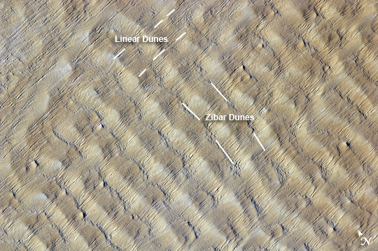 |
| Sand Dunes in the Tenere Desert, Niger This detailed astronaut photograph highlights sand dunes in the Fachi-Bilma erg (sand sea) in the central-eastern part of the Tenere Desert. The Tenere occupies much of southeastern Niger and is considered to be part of the larger Sahara Desert, which stretches across northern Africa. Much of the Sahara is comprised of ergs; with an area of approximately 150,000 square kilometers (57,915 square miles), the Fachi-Bilma is one of the larger sand seas. Two major types of dunes are visible in the image. Large, roughly north-south oriented transverse dunes fill the image frame. This type of dune tends to form at roughly right angles to the dominant, northeasterly winds. The dune crests are marked in this image by darker, steeper sand accumulations that cast shadows. The lighter-toned zones between are lower, interdune "flats." The large dunes appear to be highly symmetrical with regard to their crests. This pattern suggests that the crest sediments are coarser, preventing the formation of a steeper slip face on the downwind side of the dune by wind-driven motion of similarly sized sand grains. This particular form of transverse dune is known as a zibar, and it is thought to form by winnowing of smaller sand grains by the wind, which leaves the coarser grains to form dune crests. A second set of thin linear dunes oriented at roughly right angles to the zibar dunes appears to be formed on the larger landforms and is therefore a younger landscape feature. These dunes appear to be forming from finer grains in the same wind field as the larger zibars. |
| Images: | All Available Images Low-Resolution 299k |
|
| Mission: | ISS022 |
|
| Roll - Frame: | E - 5258 |
|
| Geographical Name: | NIGER |
|
| Features: | SAND DUNES,TENERE DESERT,ERG OF BILMA |
|
| Center Lat x Lon: | 17.2N x 11.5E |
|
| Film Exposure: | N=Normal exposure, U=Under exposed, O=Over exposed, F=out of Focus |
|
| Percentage of Cloud Cover-CLDP: | 10 |
|
| Camera:: | N2 |
|
| Camera Tilt: | 40 | LO=Low Oblique, HO=High Oblique, NV=Near Vertical |
| Camera Focal Length: | 400 |
|
| Nadir to Photo Center Direction: | NE | The direction from the nadir to the center point, N=North, S=South, E=East, W=West |
| Stereo?: | Y=Yes there is an adjacent picture of the same area, N=No there isn't |
|
| Orbit Number: | 3228 |
|
| Date: | 20091201 | YYYYMMDD |
| Time: | 064436 | GMT HHMMSS |
| Nadir Lat: | 15.7N |
Latitude of suborbital point of spacecraft |
| Nadir Lon: | 9.5E |
Longitude of suborbital point of spacecraft |
| Sun Azimuth: | 118 | Clockwise angle in degrees from north to the sun measured at the nadir point |
| Space Craft Altitude: | 181 | nautical miles |
| Sun Elevation: | 15 | Angle in degrees between the horizon and the sun, measured at the nadir point |
| Land Views: | DESERT, DUNE |
|
| Water Views: | |
|
| Atmosphere Views: | |
|
| Man Made Views: | |
|
| City Views: | |
|
Photo is not associated with any sequences | ||
| NASA Home Page |
JSC Home Page |
JSC Digital Image Collection |
Earth Science & Remote Sensing |
|
This service is provided by the International Space Station program and the JSC Earth Science & Remote Sensing Unit, ARES Division, Exploration Integration Science Directorate.

|