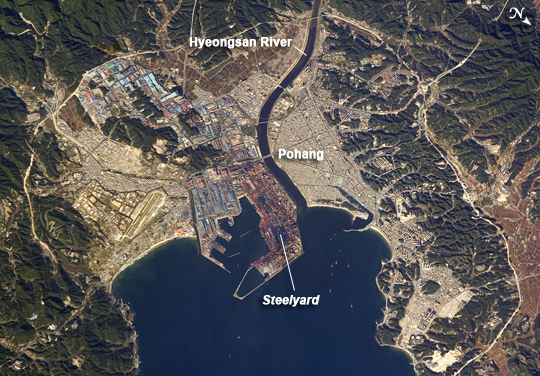
 Photo #: ISS020-E-9011 Date: Jun. 2009
Geographic Region: SOUTH KOREA
Feature: POHANG,HYEONGSAN RIVER,STEEL YARD

 Photo #: ISS020-E-9011 Date: Jun. 2009 Photo #: ISS020-E-9011 Date: Jun. 2009Geographic Region: SOUTH KOREA Feature: POHANG,HYEONGSAN RIVER,STEEL YARD |
 |
| Pohang, South Korea The port city of Pohang is located on the eastern coastline of South Korea and provides access to the East Sea and Sea of Japan. In this astronaut photo from June 12, 2009, the urban fabric of Pohang is strikingly divided by the Hyeongsan River. To the west of the river, residential and commercial development is characterized by small-footprint, gray- and white-roofed buildings connected by a dense road network. The eastern side of the river is dominated by industrial development associated with the Pohang Iron and Steel Company (POSCO) steelyard. This development (image center) includes large factory and storage buildings with striking light blue and light red rooftop. Green vegetated hills and mountains border the urban area to the east, west, and south, and several vegetated hills remain within the industrial area. Numerous boat wakes are also visible to the east-northeast of the POSCO steelyard docks. While the Pohang area has been occupied by small fishing villages since approximately 1500 BC, development of an urban area only began in 1930 when harbor facilities were constructed. POSCO began construction of a large steel mill and associated facilities in 1968, with production of steel products commencing in 1972. The steel industry is still a major component of the city's economic base, but recent efforts to lessen dependance on heavy industry has fostered new interest in environmentalism and culture within Pohang. |
| Images: | All Available Images Low-Resolution 314k |
|
| Mission: | ISS020 |
|
| Roll - Frame: | E - 9011 |
|
| Geographical Name: | SOUTH KOREA |
|
| Features: | POHANG,HYEONGSAN RIVER,STEEL YARD |
|
| Center Lat x Lon: | 36.0N x 129.4E |
|
| Film Exposure: | N=Normal exposure, U=Under exposed, O=Over exposed, F=out of Focus |
|
| Percentage of Cloud Cover-CLDP: | 10 |
|
| Camera:: | N2 |
|
| Camera Tilt: | 32 | LO=Low Oblique, HO=High Oblique, NV=Near Vertical |
| Camera Focal Length: | 400 |
|
| Nadir to Photo Center Direction: | SW | The direction from the nadir to the center point, N=North, S=South, E=East, W=West |
| Stereo?: | Y=Yes there is an adjacent picture of the same area, N=No there isn't |
|
| Orbit Number: | 528 |
|
| Date: | 20090612 | YYYYMMDD |
| Time: | 221017 | GMT HHMMSS |
| Nadir Lat: | 36.9N |
Latitude of suborbital point of spacecraft |
| Nadir Lon: | 131.1E |
Longitude of suborbital point of spacecraft |
| Sun Azimuth: | 78 | Clockwise angle in degrees from north to the sun measured at the nadir point |
| Space Craft Altitude: | 184 | nautical miles |
| Sun Elevation: | 24 | Angle in degrees between the horizon and the sun, measured at the nadir point |
| Land Views: | |
|
| Water Views: | RIVER, SEA |
|
| Atmosphere Views: | |
|
| Man Made Views: | HARBOR, PORT, URBAN AREA |
|
| City Views: | POHANG |
|
Photo is not associated with any sequences | ||
| NASA Home Page |
JSC Home Page |
JSC Digital Image Collection |
Earth Science & Remote Sensing |
|
|