
Geographic Region: USA-OREGON
Feature: MOUNT HOOD, WHITE RIVER, GOVERMENT CAMP
|
Geographic Region: USA-OREGON Feature: MOUNT HOOD, WHITE RIVER, GOVERMENT CAMP |
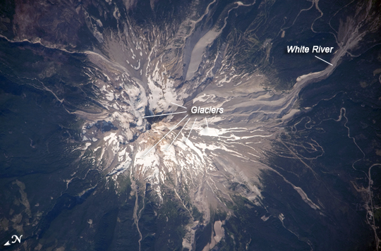 |
| Mount Hood, Oregon Mount Hood is located within the Cascade Range of the western United States, and it is the highest peak in Oregon (3,426 meters, or 11,240 feet ). The Cascade Range is characterized by a line of volcanoes associated with a slab of oceanic crust that is subducting, or descending underneath, the westward-moving, continental crust of North America. Magma generated by the subduction process rises upward through the crust and feeds a line of active volcanoes that extends from northern California in the United States to southern British Columbia in Canada. While hot springs and steam vents are still active on Mount Hood, the last eruption from the volcano occurred in 1866. The volcano is considered dormant, but still actively monitored. Separate phases of eruptive activity produced pyroclastic flows and lahars that carried erupted materials down all of the major rivers draining the volcano. Gray volcanic deposits extend southwards along the banks of the White River (image lower left) and form several prominent ridges along the southeast to southwest flanks of the volcano. The deposits contrast sharply with the green vegetation on the lower flanks of the volcano. The Mount Hood stratovolcano--a typically cone-shaped structure formed by layered lava flows and explosive eruption deposits--hosts twelve mapped glaciers along its upper flanks. Like other glaciers in the Pacific Northwest, the Hood glaciers have been receding due to global warming, and they have lost an estimated 61 percent of their volume over the past century. The predicted loss of glacial meltwater under future warming scenarios will have significant effects on regional hydrology and water supplies. |
| Images: | All Available Images Low-Resolution 214k |
|
| Mission: | ISS020 |
|
| Roll - Frame: | E - 28123 |
|
| Geographical Name: | USA-OREGON |
|
| Features: | MOUNT HOOD, WHITE RIVER, GOVERMENT CAMP |
|
| Center Lat x Lon: | 45.4N x 121.7W |
|
| Film Exposure: | N=Normal exposure, U=Under exposed, O=Over exposed, F=out of Focus |
|
| Percentage of Cloud Cover-CLDP: | 10 |
|
| Camera:: | N3 |
|
| Camera Tilt: | 26 | LO=Low Oblique, HO=High Oblique, NV=Near Vertical |
| Camera Focal Length: | 800 |
|
| Nadir to Photo Center Direction: | NW | The direction from the nadir to the center point, N=North, S=South, E=East, W=West |
| Stereo?: | Y=Yes there is an adjacent picture of the same area, N=No there isn't |
|
| Orbit Number: | 1379 |
|
| Date: | 20090805 | YYYYMMDD |
| Time: | 230929 | GMT HHMMSS |
| Nadir Lat: | 44.2N |
Latitude of suborbital point of spacecraft |
| Nadir Lon: | 120.8W |
Longitude of suborbital point of spacecraft |
| Sun Azimuth: | 249 | Clockwise angle in degrees from north to the sun measured at the nadir point |
| Space Craft Altitude: | 188 | nautical miles |
| Sun Elevation: | 43 | Angle in degrees between the horizon and the sun, measured at the nadir point |
| Land Views: | RANGE, VOLCANO |
|
| Water Views: | RIVER |
|
| Atmosphere Views: | |
|
| Man Made Views: | |
|
| City Views: | |
|
Photo is not associated with any sequences | ||
| NASA Home Page |
JSC Home Page |
JSC Digital Image Collection |
Earth Science & Remote Sensing |
|
This service is provided by the International Space Station program and the JSC Earth Science & Remote Sensing Unit, ARES Division, Exploration Integration Science Directorate.

|