Geographic Region: CHAD
Feature: AOROUNGA IMPACT CRATER,YARDANGS
|
Geographic Region: CHAD Feature: AOROUNGA IMPACT CRATER,YARDANGS |
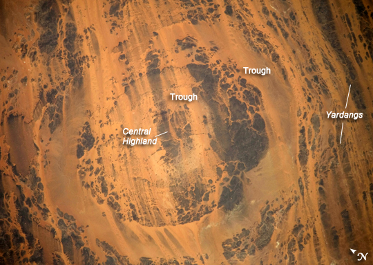 |
| Aorounga Impact Crater, Chad Aorounga Impact Crater is located in the Sahara Desert, in north-central Chad, and is one of the best preserved impact structures in the world. The crater is thought to be middle or upper Devonian to lower Mississippian (approximately 345-370 million years old) based on the age of the sedimentary rocks deformed by the impact. Spaceborne Imaging Radar (SIR) data collected in 1994 suggests that Aorounga is one of a set of three craters formed by the same impact event. The other two suggested impact structures are buried by sand deposits. The concentric ring structure of the Aorounga crater--renamed Aorounga South in the multiple-crater interpretation of SIR data--is clearly visible in this detailed astronaut photograph. The central highland, or peak, of the crater is surrounded by a small sand-filled trough; this in turn is surrounded by a larger circular trough. Linear rock ridges alternating with light orange sand deposits cross the image from upper left to lower right; these are called yardangs by geomorphologists. Yardangs form by wind erosion of exposed rock layers in a unidirectional wind field. The wind blows from the northeast at Aorounga, and sand dunes formed between the yardangs are actively migrating to the southwest. |
| Images: | All Available Images Low-Resolution 272k |
|
| Mission: | ISS020 |
|
| Roll - Frame: | E - 26195 |
|
| Geographical Name: | CHAD |
|
| Features: | AOROUNGA IMPACT CRATER,YARDANGS |
|
| Center Lat x Lon: | 19.1N x 19.2E |
|
| Film Exposure: | N=Normal exposure, U=Under exposed, O=Over exposed, F=out of Focus |
|
| Percentage of Cloud Cover-CLDP: | 10 |
|
| Camera:: | N3 |
|
| Camera Tilt: | 42 | LO=Low Oblique, HO=High Oblique, NV=Near Vertical |
| Camera Focal Length: | 800 |
|
| Nadir to Photo Center Direction: | SW | The direction from the nadir to the center point, N=North, S=South, E=East, W=West |
| Stereo?: | Y=Yes there is an adjacent picture of the same area, N=No there isn't |
|
| Orbit Number: | 1198 |
|
| Date: | 20090725 | YYYYMMDD |
| Time: | 105733 | GMT HHMMSS |
| Nadir Lat: | 21.5N |
Latitude of suborbital point of spacecraft |
| Nadir Lon: | 20.7E |
Longitude of suborbital point of spacecraft |
| Sun Azimuth: | 242 | Clockwise angle in degrees from north to the sun measured at the nadir point |
| Space Craft Altitude: | 187 | nautical miles |
| Sun Elevation: | 86 | Angle in degrees between the horizon and the sun, measured at the nadir point |
| Land Views: | CRATER, DESERT, EROSION |
|
| Water Views: | |
|
| Atmosphere Views: | |
|
| Man Made Views: | |
|
| City Views: | |
|
Photo is not associated with any sequences | ||
| NASA Home Page |
JSC Home Page |
JSC Digital Image Collection |
Earth Science & Remote Sensing |
|
This service is provided by the International Space Station program and the JSC Earth Science & Remote Sensing Unit, ARES Division, Exploration Integration Science Directorate.

|