Geographic Region: EGYPT
Feature: TOSHKA LAKES, SAND DUNES
|
Geographic Region: EGYPT Feature: TOSHKA LAKES, SAND DUNES |
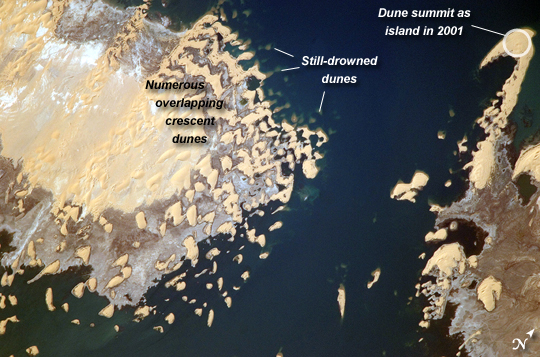 |
| Toshka Lakes, Southern Egypt In the late 1990s, Egypt's new manmade Toshka Lakes, fed from Lake Nasser via a canal, grew and spilled into new basins to become four major and two smaller lakes. These lakes extended 120 kilometers across the desert west of the Nile River in southern Egypt. Starting in 2002, astronauts have seen the lakes slowly decline, with the telltale ring of darker, moistened ground showing the previous higher water levels (see prior comparison of astronaut imagery of the lakes). The rise and fall of Toshka Lakes and the economic development surrounding the region are dependent on climate fluctuations and water agreements with upstream countries that, in turn, determine the long-term water flow in the lower Nile. This astronaut photograph, covering a distance of 11.3 kilometers from left to right, shows shoreline detail of the third large lake. Lake water appears deep blue to blue-green, and parallel with the shoreline is a wide brown zone which was under water until 2002. Most of the bright yellow sand dunes in the view are re-emerging as the lake level drops; most are outlined by thin wet margins. Still-submerged dunes can be seen offshore as blurred tan smudges (image top center). The summit of the biggest horn-shaped dune (image top right) was an island more than five kilometers offshore in images from 2001. The patterns of the overlapping crescent dunes gives a strong sense of dune migration southwards; the horns of the crescent dunes point in the direction of dune movement, from top right towards lower left. Dominant northerly winds drive the dunes southward, except, of course, when they are under water. |
| Images: | All Available Images Low-Resolution 266k |
|
| Mission: | ISS017 |
|
| Roll - Frame: | E - 8290 |
|
| Geographical Name: | EGYPT |
|
| Features: | TOSHKA LAKES, SAND DUNES |
|
| Center Lat x Lon: | 23.3N x 30.6E |
|
| Film Exposure: | N=Normal exposure, U=Under exposed, O=Over exposed, F=out of Focus |
|
| Percentage of Cloud Cover-CLDP: | 10 |
|
| Camera:: | N2 |
|
| Camera Tilt: | 32 | LO=Low Oblique, HO=High Oblique, NV=Near Vertical |
| Camera Focal Length: | 800 |
|
| Nadir to Photo Center Direction: | NW | The direction from the nadir to the center point, N=North, S=South, E=East, W=West |
| Stereo?: | Y=Yes there is an adjacent picture of the same area, N=No there isn't |
|
| Orbit Number: | 2590 |
|
| Date: | 20080531 | YYYYMMDD |
| Time: | 131737 | GMT HHMMSS |
| Nadir Lat: | 21.6N |
Latitude of suborbital point of spacecraft |
| Nadir Lon: | 31.5E |
Longitude of suborbital point of spacecraft |
| Sun Azimuth: | 281 | Clockwise angle in degrees from north to the sun measured at the nadir point |
| Space Craft Altitude: | 183 | nautical miles |
| Sun Elevation: | 42 | Angle in degrees between the horizon and the sun, measured at the nadir point |
| Land Views: | DESERT, DUNE |
|
| Water Views: | LAKE, RIVER |
|
| Atmosphere Views: | |
|
| Man Made Views: | |
|
| City Views: | |
|
Photo is not associated with any sequences | ||
| NASA Home Page |
JSC Home Page |
JSC Digital Image Collection |
Earth Science & Remote Sensing |
|
This service is provided by the International Space Station program and the JSC Earth Science & Remote Sensing Unit, ARES Division, Exploration Integration Science Directorate.

|