Geographic Region: IRELAND
Feature: BLACK HEAD, FOR., GALWAY BAY
|
Geographic Region: IRELAND Feature: BLACK HEAD, FOR., GALWAY BAY |
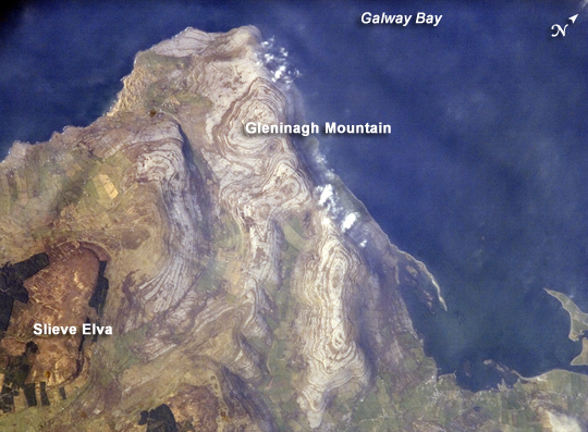 |
| Burren Plateau, County Clare, Ireland Adjoining Galway Bay to the north, the Burren (from the Gaelic for "stony place") Plateau is a example of karst terrain. Karst terrain is generally formed when sedimentary rocks are dissolved by groundwater. Most karst occurs in limestones or dolostones - rocks made primarily from the minerals calcite or dolomite. Groundwater and surface water moves through fractures in the rock, dissolving it over time, forming voids and channels. As the voids grow and connect, greater dissolution of the rock occurs; when overlying rock and soil can no longer be supported, collapse features such as sinkholes form. Over time, this can turn an originally flat landscape into one with significant topography. This astronaut photograph illustrates the northwestern-most portion of the Burren Plateau, characterized by the distinctive bare exposures of almost horizontal, layered Paleozoic limestone (light gray, with brown concentric banding) that form Gleninagh Mountain at image center. At 345 meters above sea level, Slieve Elva (image lower left) - capped with younger dark brown shale and bordered by dark green vegetation - is the highest point on the Plateau. The rounded character of limestone hills and intervening valleys of Gleninagh Mountain are the result of both dissolution of the limestone by water, and removal of loose material by past glaciers. A very thin cloud cover is visible over Gleninagh Mountain. Despite the barren character of this portion of the Burren Plateau, thin soils are present and the area is used for grazing of cattle during the wintertime. Numerous small springs - another hallmark of karst terrain, as surface streams tend to disappear underground via fractures - provide water for both cattle and human use in this otherwise dry landscape. |
| Images: | All Available Images Low-Resolution 243k |
|
| Mission: | ISS016 |
|
| Roll - Frame: | E - 30080 |
|
| Geographical Name: | IRELAND |
|
| Features: | BLACK HEAD, FOR., GALWAY BAY |
|
| Center Lat x Lon: | 53.1N x 9.2W |
|
| Film Exposure: | N=Normal exposure, U=Under exposed, O=Over exposed, F=out of Focus |
|
| Percentage of Cloud Cover-CLDP: | 10 |
|
| Camera:: | E4 |
|
| Camera Tilt: | 41 | LO=Low Oblique, HO=High Oblique, NV=Near Vertical |
| Camera Focal Length: | 800 |
|
| Nadir to Photo Center Direction: | NW | The direction from the nadir to the center point, N=North, S=South, E=East, W=West |
| Stereo?: | Y=Yes there is an adjacent picture of the same area, N=No there isn't |
|
| Orbit Number: | 950 |
|
| Date: | 20080217 | YYYYMMDD |
| Time: | 144055 | GMT HHMMSS |
| Nadir Lat: | 51.5N |
Latitude of suborbital point of spacecraft |
| Nadir Lon: | 7.2W |
Longitude of suborbital point of spacecraft |
| Sun Azimuth: | 211 | Clockwise angle in degrees from north to the sun measured at the nadir point |
| Space Craft Altitude: | 176 | nautical miles |
| Sun Elevation: | 22 | Angle in degrees between the horizon and the sun, measured at the nadir point |
| Land Views: | MOUNTAIN, PLATEAU |
|
| Water Views: | BAY |
|
| Atmosphere Views: | |
|
| Man Made Views: | |
|
| City Views: | |
|
Photo is not associated with any sequences | ||
| NASA Home Page |
JSC Home Page |
JSC Digital Image Collection |
Earth Science & Remote Sensing |
|
This service is provided by the International Space Station program and the JSC Earth Science & Remote Sensing Unit, ARES Division, Exploration Integration Science Directorate.

|