Geographic Region: EGYPT
Feature: SUEZ, GULF OF SUEZ, SUEZ CANAL
|
Geographic Region: EGYPT Feature: SUEZ, GULF OF SUEZ, SUEZ CANAL |
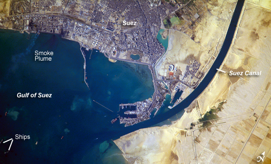 |
| Port of Suez, Egypt: The Port of Suez is located in Egypt along the northern coastline of the Gulf of Suez. The port and city mark the southern terminus of the Suez Canal, which runs north-south through Egypt from the Mediterranean Sea to the Gulf of Suez. The port serves vessels transporting general cargo, oil tankers, and both commercial and private passenger vessels. The port is also an important waypoint for Muslim pilgrims traveling to and from Mecca in Saudi Arabia. Several large vessels are visible in the Gulf of Suez and at various docks around the port. An extensive petroleum refinery complex forms the southern coastal boundary of the Port of Suez. At the time this astronaut photograph was acquired, a smoke plume extended southwards into the Gulf of Suez--probably from a facility burning off gaseous byproducts of petroleum processing. Greenish blue regions offshore in the Gulf are most likely sediments stirred up by passage of ships. Similarly colored regions along the coastline are bottom sediments visible through the clear, shallow water. |
| Images: | All Available Images Low-Resolution 257k |
|
| Mission: | ISS016 |
|
| Roll - Frame: | E - 19375 |
|
| Geographical Name: | EGYPT |
|
| Features: | SUEZ, GULF OF SUEZ, SUEZ CANAL |
|
| Center Lat x Lon: | 29.9N x 32.6E |
|
| Film Exposure: | N=Normal exposure, U=Under exposed, O=Over exposed, F=out of Focus |
|
| Percentage of Cloud Cover-CLDP: | 10 |
|
| Camera:: | E4 |
|
| Camera Tilt: | 41 | LO=Low Oblique, HO=High Oblique, NV=Near Vertical |
| Camera Focal Length: | 800 |
|
| Nadir to Photo Center Direction: | SE | The direction from the nadir to the center point, N=North, S=South, E=East, W=West |
| Stereo?: | Y=Yes there is an adjacent picture of the same area, N=No there isn't |
|
| Orbit Number: | 175 |
|
| Date: | 20071230 | YYYYMMDD |
| Time: | 125329 | GMT HHMMSS |
| Nadir Lat: | 31.5N |
Latitude of suborbital point of spacecraft |
| Nadir Lon: | 30.6E |
Longitude of suborbital point of spacecraft |
| Sun Azimuth: | 223 | Clockwise angle in degrees from north to the sun measured at the nadir point |
| Space Craft Altitude: | 179 | nautical miles |
| Sun Elevation: | 21 | Angle in degrees between the horizon and the sun, measured at the nadir point |
| Land Views: | |
|
| Water Views: | CANAL, GULF, SEA |
|
| Atmosphere Views: | PLUME, SMOKE |
|
| Man Made Views: | PORT |
|
| City Views: | SUEZ |
|
Photo is not associated with any sequences | ||
| NASA Home Page |
JSC Home Page |
JSC Digital Image Collection |
Earth Science & Remote Sensing |
|
This service is provided by the International Space Station program and the JSC Earth Science & Remote Sensing Unit, ARES Division, Exploration Integration Science Directorate.

|