Geographic Region: NICARAGUA
Feature: GULF OF FONSECA,SHRIMP FARMS
|
Geographic Region: NICARAGUA Feature: GULF OF FONSECA,SHRIMP FARMS |
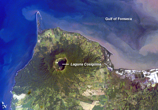 |
| Cosiguina Volcano, Nicaragua Three Central American countries--El Salvador, Honduras, and Nicaragua--have coastline along the Gulf of Fonseca, which opens into the Pacific Ocean. The southern boundary of the Gulf is a peninsula formed by the Cosiguina Volcano. Cosiguina is a stratovolcano, which is a cone-shaped volcano formed by alternating layers of solidified lava and volcanic rocks produced by explosive eruptions. The summit crater is filled with a lake (Laguna Cosiguina). The volcano last erupted in 1859, but its most famous activity occurred in 1835, when it produced the largest historical eruption in Nicaragua. Ash from the 1835 eruption has been found in Mexico, Costa Rica, and Jamaica. The volcano has been quiet since 1859, only an instant in terms of geological time. An earthquake swarm was measured near Cosiguina in 2002, indicating that tectonic forces are still active in the region although the volcano is somewhat isolated from the line of more recently active Central American volcanoes to the northwest and southeast. The only indicators of hydrothermal activity at the volcano are intermittently observed gas bubbles in Laguna Cosiguina and a hot spring along the eastern flank of the volcano. The fairly uniform vegetation cover (green) on the volcano's sides also attest to a general lack of gas emissions or "hot spots" on the 872-meter-high cone. |
| Images: | All Available Images Low-Resolution 307k |
|
| Mission: | ISS016 |
|
| Roll - Frame: | E - 10894 |
|
| Geographical Name: | NICARAGUA |
|
| Features: | GULF OF FONSECA,SHRIMP FARMS |
|
| Center Lat x Lon: | 13.0N x 87.4W |
|
| Film Exposure: | N=Normal exposure, U=Under exposed, O=Over exposed, F=out of Focus |
|
| Percentage of Cloud Cover-CLDP: | 10 |
|
| Camera:: | E4 |
|
| Camera Tilt: | 2 | LO=Low Oblique, HO=High Oblique, NV=Near Vertical |
| Camera Focal Length: | 180 |
|
| Nadir to Photo Center Direction: | E | The direction from the nadir to the center point, N=North, S=South, E=East, W=West |
| Stereo?: | Y=Yes there is an adjacent picture of the same area, N=No there isn't |
|
| Orbit Number: | 3498 |
|
| Date: | 20071117 | YYYYMMDD |
| Time: | 153324 | GMT HHMMSS |
| Nadir Lat: | 13.0N |
Latitude of suborbital point of spacecraft |
| Nadir Lon: | 87.5W |
Longitude of suborbital point of spacecraft |
| Sun Azimuth: | 136 | Clockwise angle in degrees from north to the sun measured at the nadir point |
| Space Craft Altitude: | 183 | nautical miles |
| Sun Elevation: | 46 | Angle in degrees between the horizon and the sun, measured at the nadir point |
| Land Views: | CRATER, PENINSULA, VOLCANO |
|
| Water Views: | GULF, LAKE, OCEAN |
|
| Atmosphere Views: | |
|
| Man Made Views: | |
|
| City Views: | |
|
Photo is not associated with any sequences | ||
| NASA Home Page |
JSC Home Page |
JSC Digital Image Collection |
Earth Science & Remote Sensing |
|
This service is provided by the International Space Station program and the JSC Earth Science & Remote Sensing Unit, ARES Division, Exploration Integration Science Directorate.

|