Geographic Region: USA-FLORIDA
Feature: FLORIDA B., CAN., MARSH, ROADS
|
Geographic Region: USA-FLORIDA Feature: FLORIDA B., CAN., MARSH, ROADS |
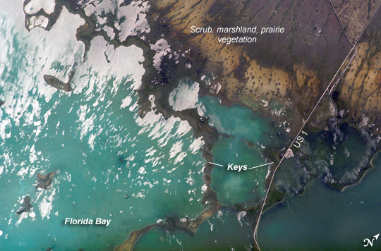 |
| Southern Everglades National Park, Florida: Everglades National Park in southern Florida is the largest subtropical wilderness in the United States. Known as the "river of grass," the Everglades wetlands and wooded uplands host a variety of endangered species including crocodiles, manatees, and panthers. During the late nineteenth and twentieth centuries, the original 11,000 square miles of wetlands were viewed as useless swampland in need of reclamation. The success of reclamation efforts--for agriculture and urban expansion in southern Florida--has led to the loss of approximately 50 percent of the original wetlands and 90 percent of wading bird species. Today, an extensive restoration effort is underway to return portions of the Everglades to a more natural state and prevent further ecosystem degradation. This astronaut photograph highlights the southern Everglades, where the wetlands meet Florida Bay. Thin fingers of land and small islands (keys) host mangrove, hardwood hammocks (tree-covered mounds), marsh and prairie (mainly dark to light green in the image). The tan and grayish-brown areas at image upper right are dominantly scrub, marshland and prairie; small green "dots" and narrow lines in this region are isolated mangrove and hardwood stands indicating the general direction of slow water flow toward the bay. The silver-gray regions at image left are water surfaces highlighted by sunglint, light reflected off the water surface directly back towards the astronaut aboard the International Space Station. The roadway forming the western boundary of the National Park is U.S. Route 1, which connects the Miami metropolitan area to the north (not shown) with the Florida Keys to the south (not shown). A small tan patch visible along the roadway is a fishing camp. |
| Images: | All Available Images Low-Resolution 273k |
|
| Mission: | ISS015 |
|
| Roll - Frame: | E - 8920 |
|
| Geographical Name: | USA-FLORIDA |
|
| Features: | FLORIDA B., CAN., MARSH, ROADS |
|
| Center Lat x Lon: | 25.2N x 80.5W |
|
| Film Exposure: | N=Normal exposure, U=Under exposed, O=Over exposed, F=out of Focus |
|
| Percentage of Cloud Cover-CLDP: | 10 |
|
| Camera:: | E4 |
|
| Camera Tilt: | 52 | LO=Low Oblique, HO=High Oblique, NV=Near Vertical |
| Camera Focal Length: | 400 |
|
| Nadir to Photo Center Direction: | NW | The direction from the nadir to the center point, N=North, S=South, E=East, W=West |
| Stereo?: | Y=Yes there is an adjacent picture of the same area, N=No there isn't |
|
| Orbit Number: | 627 |
|
| Date: | 20070519 | YYYYMMDD |
| Time: | 165453 | GMT HHMMSS |
| Nadir Lat: | 22.1N |
Latitude of suborbital point of spacecraft |
| Nadir Lon: | 78.3W |
Longitude of suborbital point of spacecraft |
| Sun Azimuth: | 122 | Clockwise angle in degrees from north to the sun measured at the nadir point |
| Space Craft Altitude: | 178 | nautical miles |
| Sun Elevation: | 86 | Angle in degrees between the horizon and the sun, measured at the nadir point |
| Land Views: | |
|
| Water Views: | BAY, RIVER, SUNGLINT |
|
| Atmosphere Views: | |
|
| Man Made Views: | AGRICULTURE |
|
| City Views: | |
|
Photo is not associated with any sequences | ||
| NASA Home Page |
JSC Home Page |
JSC Digital Image Collection |
Earth Science & Remote Sensing |
|
This service is provided by the International Space Station program and the JSC Earth Science & Remote Sensing Unit, ARES Division, Exploration Integration Science Directorate.

|