Geographic Region: USA-LOUISIANA
Feature: MARSH ISLAND, SUNGLINT
|
Geographic Region: USA-LOUISIANA Feature: MARSH ISLAND, SUNGLINT |
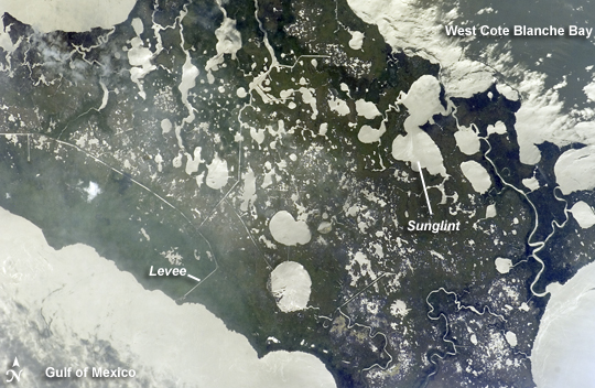 |
| ISS015-E-07725 (11 May 2007) --- Marsh Island, Louisiana is featured in this image photographed by an Expedition 15 crewmember on the International Space Station. Marsh Island, located along the southwestern coastline of Louisiana, is a remnant of an abandoned lobe of the Mississippi River Delta formed approximately 5000-7500 years before the present day, according to scientists. It is composed primarily of organic-rich muds and brackish marsh vegetation (some peat -- semiconsolidated plant and organic matter -- is also present). The intricate lake, pond and stream network of the island is highlighted in this image by silver-gray sunglint -- light reflected off of water surfaces directly back to the crewmember on the space station. Sunglint also illuminates water surfaces in the adjacent Gulf of Mexico and West Cote Blanche Bay -- variations in intensity of reflectance in these water bodies is due to surface roughness (often related to wind-driven waves or currents) and the presence of surfactants that can change the surface properties of the water. Marsh Island is a popular fishing, shrimping and birding location. The island has experienced significant loss of vegetation and land area -- nearly 3,000 hectares (7,000 acres) - due to erosion, with a corresponding loss of habitat for local and migratory birds, shrimp, alligators and deer. While Marsh Island is uninhabited, it has been the focus of intensive development for management of erosion, such as revegetation of deteriorated marsh areas. Leveed canals (straight silver-gray water features) help drain areas for above-surface revegetation, while sill dams help stabilize water levels and foster regrowth of important subsurface vegetation such as widgeongrass. Marsh Island, Louisiana: Marsh Island, located along the southwestern coastline of Louisiana, is a remnant of an abandoned lobe of the Mississippi River Delta formed approximately 5,000-7,500 years ago. It is composed primarily of organic-rich muds and brackish marsh vegetation, but some peat (layers of vegetation that have partially decomposed while submerged in water) is also present. In this astronaut photograph, silver-gray sunglint highlights the intricate network of lakes, ponds, and streams on the island. (Sunglint is the mirror-like reflection of sunlight off water surfaces directly back to the astronaut onboard the International Space Station.) Sunglint also illuminates water surfaces in the adjacent Gulf of Mexico and West Cote Blanche Bay. The variations in brightness comes from differences in surface roughness, which changes based on wind-driven waves or currents and the presence of surfactants--molecules that reduce the water's surface tension. Synthetic detergents are surfactants, but natural surfactants are also produced by plants, including seaweed. Marsh Island is a popular fishing, shrimping, and birding location. The island has lost nearly 3,000 hectares (7,000 acres) of vegetation and land area due to erosion, with a corresponding loss of habitat for local and migratory birds, shrimp, alligators, and deer. While Marsh Island is uninhabited, it has been the focus of intensive development for management of erosion, such as revegetation of deteriorated marsh areas. Leveed canals help drain areas for above-surface revegetation, while sill dams (submerged ridges that separate two water basins) help stabilize water levels and foster regrowth of important sub-surface vegetation such as widgeon grass. |
| Images: | All Available Images Low-Resolution 228k |
|
| Mission: | ISS015 |
|
| Roll - Frame: | E - 7725 |
|
| Geographical Name: | USA-LOUISIANA |
|
| Features: | MARSH ISLAND, SUNGLINT |
|
| Center Lat x Lon: | 29.6N x 91.8W |
|
| Film Exposure: | N=Normal exposure, U=Under exposed, O=Over exposed, F=out of Focus |
|
| Percentage of Cloud Cover-CLDP: | 10 |
|
| Camera:: | E4 |
|
| Camera Tilt: | 23 | LO=Low Oblique, HO=High Oblique, NV=Near Vertical |
| Camera Focal Length: | 400 |
|
| Nadir to Photo Center Direction: | S | The direction from the nadir to the center point, N=North, S=South, E=East, W=West |
| Stereo?: | Y=Yes there is an adjacent picture of the same area, N=No there isn't |
|
| Orbit Number: | 503 |
|
| Date: | 20070511 | YYYYMMDD |
| Time: | 202324 | GMT HHMMSS |
| Nadir Lat: | 30.8N |
Latitude of suborbital point of spacecraft |
| Nadir Lon: | 91.4W |
Longitude of suborbital point of spacecraft |
| Sun Azimuth: | 257 | Clockwise angle in degrees from north to the sun measured at the nadir point |
| Space Craft Altitude: | 177 | nautical miles |
| Sun Elevation: | 56 | Angle in degrees between the horizon and the sun, measured at the nadir point |
| Land Views: | EROSION, ISLAND |
|
| Water Views: | BAY, DELTA, GULF, LAKE, RIVER, SUNGLINT |
|
| Atmosphere Views: | |
|
| Man Made Views: | |
|
| City Views: | |
|
Photo is not associated with any sequences | ||
| NASA Home Page |
JSC Home Page |
JSC Digital Image Collection |
Earth Science & Remote Sensing |
|
This service is provided by the International Space Station program and the JSC Earth Science & Remote Sensing Unit, ARES Division, Exploration Integration Science Directorate.

|