
Geographic Region: USA-UTAH
Feature: GREAT SALT LAKE,PLANKTON BLOOM
|
Geographic Region: USA-UTAH Feature: GREAT SALT LAKE,PLANKTON BLOOM |
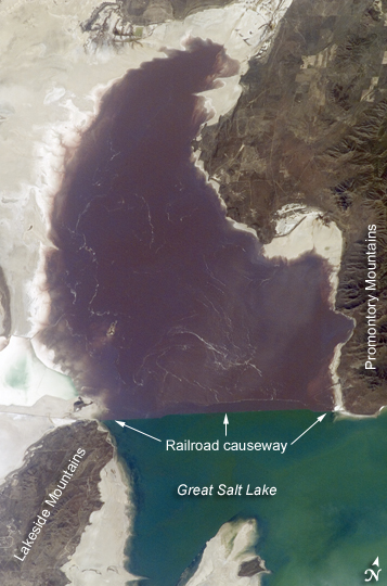 |
| Algae in Great Salt Lake: The Great Salt Lake of northern Utah is a remnant of glacial Lake Bonneville that extended over much of present-day western Utah and into the neighboring states of Nevada and Idaho approximately 32,000 to 14,000 years ago. During this time, the peaks of adjacent ranges such as the Promontory and Lakeside Mountains were most likely islands. As climate warmed and precipitation decreased in the region, glaciers that fed meltwater to Lake Bonneville disappeared, and the lake began to dry up. The present-day Great Salt Lake is a terminal lake in that water does not flow out of the lake basin. Water loss through the year is due primarily to evaporation, and when this loss exceeds input of water from rivers, streams, precipitation, and groundwater, the lake level decreases. This is particularly evident during droughts. Evaporation and the relatively shallow water levels (maximum lake depth is around 33 feet), has led to increased salinity (dissolved salt content). The north arm of the lake, displayed in this astronaut photograph from April 30, 2007, typically has twice the salinity of the rest of the lake due to impoundment of water by a railroad causeway that crosses the lake from east to west. The causeway restricts water flow, and the separation has led to a striking division in the types of algae and bacteria found in the north and south arms of the lake. North of the causeway, the red algae Dunaliella salina and the bacterial species Halobacterium produce a pronounced reddish cast to the water, whereas south of the causeway, the water color is dominated by green algae such as Dunaliella viridis. The Great Salt Lake also supports brine shrimp and brine flies; and it is a major stopover point for migratory birds including avocets, stilts, and plovers. |
| Images: | All Available Images Low-Resolution 187k |
|
| Mission: | ISS015 |
|
| Roll - Frame: | E - 5815 |
|
| Geographical Name: | USA-UTAH |
|
| Features: | GREAT SALT LAKE,PLANKTON BLOOM |
|
| Center Lat x Lon: | 41.4N x 112.7W |
|
| Film Exposure: | N=Normal exposure, U=Under exposed, O=Over exposed, F=out of Focus |
|
| Percentage of Cloud Cover-CLDP: | 10 |
|
| Camera:: | E4 |
|
| Camera Tilt: | HO | LO=Low Oblique, HO=High Oblique, NV=Near Vertical |
| Camera Focal Length: | 180 |
|
| Nadir to Photo Center Direction: | E | The direction from the nadir to the center point, N=North, S=South, E=East, W=West |
| Stereo?: | Y=Yes there is an adjacent picture of the same area, N=No there isn't |
|
| Orbit Number: | 329 |
|
| Date: | 20070430 | YYYYMMDD |
| Time: | 193057 | GMT HHMMSS |
| Nadir Lat: | 41.1N |
Latitude of suborbital point of spacecraft |
| Nadir Lon: | 119.1W |
Longitude of suborbital point of spacecraft |
| Sun Azimuth: | 168 | Clockwise angle in degrees from north to the sun measured at the nadir point |
| Space Craft Altitude: | 178 | nautical miles |
| Sun Elevation: | 63 | Angle in degrees between the horizon and the sun, measured at the nadir point |
| Land Views: | BASIN |
|
| Water Views: | LAKE |
|
| Atmosphere Views: | |
|
| Man Made Views: | |
|
| City Views: | |
|
Photo is not associated with any sequences | ||
| NASA Home Page |
JSC Home Page |
JSC Digital Image Collection |
Earth Science & Remote Sensing |
|
This service is provided by the International Space Station program and the JSC Earth Science & Remote Sensing Unit, ARES Division, Exploration Integration Science Directorate.

|