
Geographic Region: USA-NEW YORK
Feature: NEW ENGLAND, LONG I., SMOG
|
Geographic Region: USA-NEW YORK Feature: NEW ENGLAND, LONG I., SMOG |
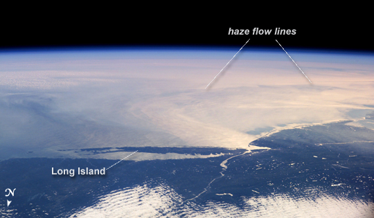 |
| ISS014-E-07738 (10 Nov. 2006) --- This image featuring a southeast-looking view of the Long Island Sound and New Jersey coast, with the lower Hudson River and New York Bay in the area of brightest sunglint was photographed by an Expedition 14 crewmember on the International Space Station. On the far right a gray haze can be seen streaming out to sea offshore of New Jersey, where it becomes harder to see. In fact haze covers most of the visible area offshore, partly obscuring the sea surface. By contrast, clouds look quite different from haze according to scientists. Clouds usually have sharp margins and are pure white, as clouds at the bottom show. Industrial haze is grayer and more diffuse, and is typical of the air over the Northeast. Flow lines show that winds are transporting the haze in clockwise fashion--i.e. bending south--which in turn signifies that a high pressure system was operating on that day, centered roughly over the coast. High pressure systems are notorious for promoting smog events because they bring clear skies, and sunlight promotes smog formation. Highs also concentrate polluted surface layers near the ground. |
| Images: | All Available Images Low-Resolution 130k |
|
| Mission: | ISS014 |
|
| Roll - Frame: | E - 7738 |
|
| Geographical Name: | USA-NEW YORK |
|
| Features: | NEW ENGLAND, LONG I., SMOG |
|
| Center Lat x Lon: | 40.0N x 73.5W |
|
| Film Exposure: | N=Normal exposure, U=Under exposed, O=Over exposed, F=out of Focus |
|
| Percentage of Cloud Cover-CLDP: | 25 |
|
| Camera:: | E4 |
|
| Camera Tilt: | HO | LO=Low Oblique, HO=High Oblique, NV=Near Vertical |
| Camera Focal Length: | 80 |
|
| Nadir to Photo Center Direction: | S | The direction from the nadir to the center point, N=North, S=South, E=East, W=West |
| Stereo?: | Y=Yes there is an adjacent picture of the same area, N=No there isn't |
|
| Orbit Number: | 1627 |
|
| Date: | 20061110 | YYYYMMDD |
| Time: | 162326 | GMT HHMMSS |
| Nadir Lat: | 49.4N |
Latitude of suborbital point of spacecraft |
| Nadir Lon: | 76.5W |
Longitude of suborbital point of spacecraft |
| Sun Azimuth: | 173 | Clockwise angle in degrees from north to the sun measured at the nadir point |
| Space Craft Altitude: | 180 | nautical miles |
| Sun Elevation: | 23 | Angle in degrees between the horizon and the sun, measured at the nadir point |
| Land Views: | COAST, ISLAND |
|
| Water Views: | BAY, RIVER, SEA, SUNGLINT |
|
| Atmosphere Views: | HAZE, SMOG |
|
| Man Made Views: | |
|
| City Views: | |
|
Photo is not associated with any sequences | ||
| NASA Home Page |
JSC Home Page |
JSC Digital Image Collection |
Earth Science & Remote Sensing |
|
This service is provided by the International Space Station program and the JSC Earth Science & Remote Sensing Unit, ARES Division, Exploration Integration Science Directorate.

|