Geographic Region: SPAIN
Feature: GIBRALTAR, ALGECIRAS, SHIPS
|
Geographic Region: SPAIN Feature: GIBRALTAR, ALGECIRAS, SHIPS |
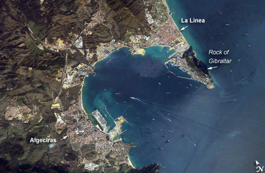 |
| Gibraltar Bay, Western Mediterranean Sea: Gibraltar Bay, located near the southernmost tip of the Iberian Peninsula, is the central feature of this astronaut photograph. The famous Rock of Gibraltar that forms the northeastern border of the bay is formed of Jurassic-era seafloor sediments that solidified into limestone, a rock formed mostly of the mineral calcite, which is found in the shells of sea creatures. The limestone was subsequently lifted above the ocean surface when the African and Eurasian tectonic plates collided. The cities of La Linea and Algeciras bordering the bay, together with petroleum-processing facilities along the northern shoreline, are part of Spain, whereas the city of Gibraltar itself (to the west of and including the Rock) is under the jurisdiction of the United Kingdom. The protected waters of Gibraltar Bay and its location close to Africa and the Strait of Gibraltar (the gateway between the Atlantic Ocean and the Mediterranean Sea), contribute to the region's past and current strategic and economic importance. Numerous ships and several ship wakes are visible within the bay; the majority of these are freighters and cargo tankers accessing the petroleum facilities. Ships nearer to the Rock of Gibraltar are more likely cruise ships, as Gibraltar is a popular destination for tourists. Partial sunglint (light reflected directly back to the camera onboard the International Space Station) within the bay highlights surface water roughened by winds funneled into the bay by the surrounding highlands. One such area is visible directly to the west of La Linea. |
| Images: | All Available Images Low-Resolution 283k |
|
| Mission: | ISS014 |
|
| Roll - Frame: | E - 6812 |
|
| Geographical Name: | SPAIN |
|
| Features: | GIBRALTAR, ALGECIRAS, SHIPS |
|
| Center Lat x Lon: | 36.2N x 5.4W |
|
| Film Exposure: | N=Normal exposure, U=Under exposed, O=Over exposed, F=out of Focus |
|
| Percentage of Cloud Cover-CLDP: | 10 |
|
| Camera:: | E4 |
|
| Camera Tilt: | 35 | LO=Low Oblique, HO=High Oblique, NV=Near Vertical |
| Camera Focal Length: | 400 |
|
| Nadir to Photo Center Direction: | S | The direction from the nadir to the center point, N=North, S=South, E=East, W=West |
| Stereo?: | Y=Yes there is an adjacent picture of the same area, N=No there isn't |
|
| Orbit Number: | 1452 |
|
| Date: | 20061030 | YYYYMMDD |
| Time: | 141532 | GMT HHMMSS |
| Nadir Lat: | 38.2N |
Latitude of suborbital point of spacecraft |
| Nadir Lon: | 4.7W |
Longitude of suborbital point of spacecraft |
| Sun Azimuth: | 218 | Clockwise angle in degrees from north to the sun measured at the nadir point |
| Space Craft Altitude: | 180 | nautical miles |
| Sun Elevation: | 29 | Angle in degrees between the horizon and the sun, measured at the nadir point |
| Land Views: | PENINSULA |
|
| Water Views: | BAY, OCEAN, SEA, STRAIT, SUNGLINT |
|
| Atmosphere Views: | |
|
| Man Made Views: | |
|
| City Views: | ALGECIRAS |
|
Photo is not associated with any sequences | ||
| NASA Home Page |
JSC Home Page |
JSC Digital Image Collection |
Earth Science & Remote Sensing |
|
This service is provided by the International Space Station program and the JSC Earth Science & Remote Sensing Unit, ARES Division, Exploration Integration Science Directorate.

|