
Geographic Region: CANADA-Q
Feature: MONTREAL, SNOW, MONT ROYAL, R.
|
Geographic Region: CANADA-Q Feature: MONTREAL, SNOW, MONT ROYAL, R. |
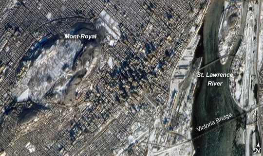 |
| Montreal The largest city in the Canadian province of Quebec and the largest inland port in the world, Montreal takes its name from a distinctive landscape feature at the center of the city. Mont-Royal ("royal mountain" in French) rises to an elevation of 233 meters (about 764 feet) at Colline de la Croix peak. The mountain is sometimes identified in guidebooks as an extinct volcano, but the types of igneous rock found at Mont-Royal suggest the mountain is more likely to be the remnants of magma chambers that once fed surface volcanoes than a surface volcano itself. The Parc du Mont-Royal--one of the city's largest forested greenspaces--is located on the lower slopes of the mountain (appearing as gray-green regions in the image), while the Notre-Dame-des-Neiges Cemetery occupies most of the upper snow-covered area of Mont-Royal visible in the image. This astronaut photograph was taken while the International Space Station (ISS) was located approximately 306 kilometers (about 190 miles) to the southeast over Mount Vernon, Maine. The astronaut was looking northwest to capture the morning sunlight on a snow-dusted Montreal. Individual skyscrapers of the downtown area are clearly visible, highlighted by the long shadows they cast in the light of the rising sun. The high-rise profile of the downtown area contrasts sharply with a distinctive grid pattern of residential, commercial, and institutional city blocks to the north, south, and west, which are outlined by the snow cover. The combination of oblique viewing angle and sun position also allow for the capture of sunglint--light reflected directly back to the camera on the ISS--on the St. Lawrence River at image right. The glint reveals ice on the river; several large chunks are visible to the north of the Victoria Bridge (image lower right). The image is detailed enough to capture individual support pylons on the bridge. |
| Images: | All Available Images Low-Resolution 250k |
|
| Mission: | ISS014 |
|
| Roll - Frame: | E - 12652 |
|
| Geographical Name: | CANADA-Q |
|
| Features: | MONTREAL, SNOW, MONT ROYAL, R. |
|
| Center Lat x Lon: | 45.5N x 73.6W |
|
| Film Exposure: | N=Normal exposure, U=Under exposed, O=Over exposed, F=out of Focus |
|
| Percentage of Cloud Cover-CLDP: | 10 |
|
| Camera:: | E4 |
|
| Camera Tilt: | 53 | LO=Low Oblique, HO=High Oblique, NV=Near Vertical |
| Camera Focal Length: | 800 |
|
| Nadir to Photo Center Direction: | W | The direction from the nadir to the center point, N=North, S=South, E=East, W=West |
| Stereo?: | Y=Yes there is an adjacent picture of the same area, N=No there isn't |
|
| Orbit Number: | 2762 |
|
| Date: | 20070121 | YYYYMMDD |
| Time: | 144006 | GMT HHMMSS |
| Nadir Lat: | 44.5N |
Latitude of suborbital point of spacecraft |
| Nadir Lon: | 70W |
Longitude of suborbital point of spacecraft |
| Sun Azimuth: | 147 | Clockwise angle in degrees from north to the sun measured at the nadir point |
| Space Craft Altitude: | 171 | nautical miles |
| Sun Elevation: | 19 | Angle in degrees between the horizon and the sun, measured at the nadir point |
| Land Views: | MOUNTAIN |
|
| Water Views: | ICE, RIVER, SUNGLINT |
|
| Atmosphere Views: | |
|
| Man Made Views: | BRIDGE, PORT |
|
| City Views: | MONTREAL |
|
Photo is not associated with any sequences | ||
| NASA Home Page |
JSC Home Page |
JSC Digital Image Collection |
Earth Science & Remote Sensing |
|
This service is provided by the International Space Station program and the JSC Earth Science & Remote Sensing Unit, ARES Division, Exploration Integration Science Directorate.

|