Geographic Region: ITALY
Feature: PAN-ALPS, PO R. VALLY, SMOG
|
Geographic Region: ITALY Feature: PAN-ALPS, PO R. VALLY, SMOG |
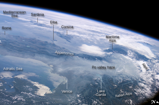 |
| Haze in the Po River Valley, Italy: Taken from an oblique angle and looking toward the southwest, this astronaut photograph shows parts of northern Italy, Corsica, Sardinia, the Adriatic Sea, and the Mediterranean. Over part of the Alps, skies are clear, but elsewhere, the view of the land and sea is largely obscured. Bright white clouds cover much of the region, but over northern Italy, the "clouds" are different. There, dingy, gray-blue haze hangs over the Po River Valley. The Po River, Italy's longest river, runs approximately 650 kilometers (400 miles) from the southwestern Alps to the Adriatic Sea, passing indirectly through Milan, and through Turin. As Turin is an industrial center of a heavily urbanized region, pollutants often cloud the skies overhead. In fact, northern Italy is one of Europe's pollution hotspots, and the smog often grows thick enough to be seen from space. Smog in this area is so persistent that astronauts on the International Space Station have photographed other images of it, in October 1997 and February 2003. Recurring accumulations of smog in the Po River Valley, however, result from more than just the industrial emissions from the area around Turin. In this area, smog is often trapped at the base of the Alps by high atmospheric pressure. |
| Images: | All Available Images Low-Resolution 174k |
|
| Mission: | ISS013 |
|
| Roll - Frame: | E - 78295 |
|
| Geographical Name: | ITALY |
|
| Features: | PAN-ALPS, PO R. VALLY, SMOG |
|
| Center Lat x Lon: | 44.0N x 10.0E |
|
| Film Exposure: | N=Normal exposure, U=Under exposed, O=Over exposed, F=out of Focus |
|
| Percentage of Cloud Cover-CLDP: | 25 |
|
| Camera:: | E4 |
|
| Camera Tilt: | HO | LO=Low Oblique, HO=High Oblique, NV=Near Vertical |
| Camera Focal Length: | 38 |
|
| Nadir to Photo Center Direction: | SW | The direction from the nadir to the center point, N=North, S=South, E=East, W=West |
| Stereo?: | Y=Yes there is an adjacent picture of the same area, N=No there isn't |
|
| Orbit Number: | 599 |
|
| Date: | 20060906 | YYYYMMDD |
| Time: | 123809 | GMT HHMMSS |
| Nadir Lat: | 48.6N |
Latitude of suborbital point of spacecraft |
| Nadir Lon: | 16.8E |
Longitude of suborbital point of spacecraft |
| Sun Azimuth: | 217 | Clockwise angle in degrees from north to the sun measured at the nadir point |
| Space Craft Altitude: | 184 | nautical miles |
| Sun Elevation: | 42 | Angle in degrees between the horizon and the sun, measured at the nadir point |
| Land Views: | VALLEY |
|
| Water Views: | RIVER, SEA |
|
| Atmosphere Views: | HAZE, SMOG |
|
| Man Made Views: | POLLUTION |
|
| City Views: | VENICE |
|
Photo is not associated with any sequences | ||
| NASA Home Page |
JSC Home Page |
JSC Digital Image Collection |
Earth Science & Remote Sensing |
|
This service is provided by the International Space Station program and the JSC Earth Science & Remote Sensing Unit, ARES Division, Exploration Integration Science Directorate.

|