Geographic Region: PERU
Feature: UBINAS VOLCANO,ASH CLOUD
|
Geographic Region: PERU Feature: UBINAS VOLCANO,ASH CLOUD |
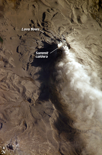 |
| Ash Cloud from Mount Ubinas, Peru Subduction of the Nazca tectonic plate along the western coast of South America forms the high Peruvian Andes. The subduction (movement of one plate beneath another) also produces magma, feeding a chain of historically active volcanoes along the western front of the mountains. The most active of these volcanoes in Peru is Ubinas. A typical, steep-sided stratovolcano comprised primarily of layers of silica-rich lava flows, it has a summit elevation of 5,672 meters (18,609 feet). At 1.4 kilometers (0.87 miles) across, the volcano's caldera gives it a truncated profile. Hardened lava flows from past eruptions linger on the volcano's flanks. This oblique image (looking at an angle) from the International Space Station (ISS) captures an ash cloud first observed on satellite imagery at 11:00 GMT on August 14, 2006. An ISS astronaut took this picture one hour and 45 minutes later. The ash cloud caused the Buenos Aires Volcanic Ash Advisory Center to issue an aviation hazard warning. Minor to moderately explosive eruptions of ash and pumice characterize modern activity at Ubinas. Pumice and ash blanket the volcanic cone and surrounding area, giving this image an overall gray appearance. Shadowing of the western flank of Ubinas throws several lava flows into sharp relief, and highlights the steep slopes at the flow fronts--common characteristics of thick, slow-moving lavas. The most recent major eruption of Ubinas occurred in 1969, although its historical record of activity extends back to the 16th century. |
| Images: | All Available Images Low-Resolution 229k |
|
| Mission: | ISS013 |
|
| Roll - Frame: | E - 66488 |
|
| Geographical Name: | PERU |
|
| Features: | UBINAS VOLCANO,ASH CLOUD |
|
| Center Lat x Lon: | 16.3S x 70.9W |
|
| Film Exposure: | N=Normal exposure, U=Under exposed, O=Over exposed, F=out of Focus |
|
| Percentage of Cloud Cover-CLDP: | 10 |
|
| Camera:: | E4 |
|
| Camera Tilt: | 38 | LO=Low Oblique, HO=High Oblique, NV=Near Vertical |
| Camera Focal Length: | 800 |
|
| Nadir to Photo Center Direction: | N | The direction from the nadir to the center point, N=North, S=South, E=East, W=West |
| Stereo?: | Y=Yes there is an adjacent picture of the same area, N=No there isn't |
|
| Orbit Number: | 236 |
|
| Date: | 20060814 | YYYYMMDD |
| Time: | 124359 | GMT HHMMSS |
| Nadir Lat: | 18.6S |
Latitude of suborbital point of spacecraft |
| Nadir Lon: | 71.6W |
Longitude of suborbital point of spacecraft |
| Sun Azimuth: | 66 | Clockwise angle in degrees from north to the sun measured at the nadir point |
| Space Craft Altitude: | 183 | nautical miles |
| Sun Elevation: | 21 | Angle in degrees between the horizon and the sun, measured at the nadir point |
| Land Views: | CALDERA, VOLCANO |
|
| Water Views: | |
|
| Atmosphere Views: | PLUME |
|
| Man Made Views: | |
|
| City Views: | |
|
Photo is not associated with any sequences | ||
| NASA Home Page |
JSC Home Page |
JSC Digital Image Collection |
Earth Science & Remote Sensing |
|
This service is provided by the International Space Station program and the JSC Earth Science & Remote Sensing Unit, ARES Division, Exploration Integration Science Directorate.

|