 Photo #: ISS013-E-27872 Date: May 2006
Geographic Region: USA-OHIO
Feature: VERMILION R.,LAKE ERIE,GLINT

 Photo #: ISS013-E-27872 Date: May 2006 Photo #: ISS013-E-27872 Date: May 2006Geographic Region: USA-OHIO Feature: VERMILION R.,LAKE ERIE,GLINT |
 |
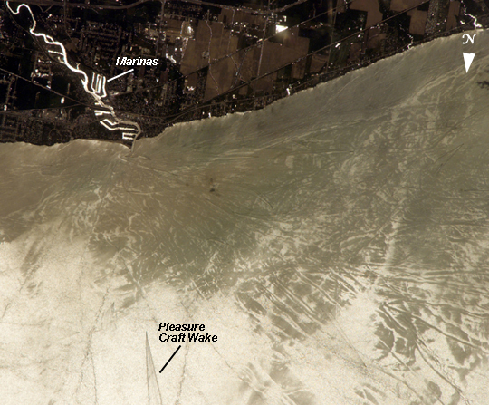
| Sunglint Features, Lake Erie, United States Three detailed south-looking images, taken one second apart near noon on May 28th, 2006, show features on the surface of Lake Erie, about 50 kilometers (30 miles) west of Cleveland, Ohio. The three images overlap slightly and are aligned similarly with south at image top. The top image shows the Vermilion River in strong sunglint (top left). Sunglint results when the Sun's light bounces off the water's surface and into the satellite sensor or camera. The angular water bodies along the river are likely marinas. The main part of the image shows numerous ship wakes in the zone of partial glint around the disk of the Sun's reflection point. The wakes radiate from the mouth of the Vermilion River, with many of them heading northwest (towards the lower-right corner) in the direction of Detroit, Michigan. On the left side of the second image, a thin, V-shaped wake curves back towards the shore (and appears near the lower left in the top image). This type of wake is typically created by a small, light craft such as a speedboat or sailboat under power. The third image shows similar tight-V-shaped wakes of other small craft. It also shows broad patterns of larger craft, probably large freighters carrying cargo, that displace and disturb more water during passage. These larger wakes are aligned with the direct course between Detroit (out of the image at lower right) and Cleveland (out of the image at top left). Some of the broad, ill-defined swaths of light and dark (aligned from lower left to upper right) are streaks of wind-roughened water, which reflect the Sun differently. |
| Images: | All Available Images Low-Resolution 295k |
|
| Mission: | ISS013 |
|
| Roll - Frame: | E - 27872 |
|
| Geographical Name: | USA-OHIO |
|
| Features: | VERMILION R.,LAKE ERIE,GLINT |
|
| Center Lat x Lon: | 41.5N x 82.4W |
|
| Film Exposure: | N=Normal exposure, U=Under exposed, O=Over exposed, F=out of Focus |
|
| Percentage of Cloud Cover-CLDP: | 10 |
|
| Camera:: | E4 |
|
| Camera Tilt: | 31 | LO=Low Oblique, HO=High Oblique, NV=Near Vertical |
| Camera Focal Length: | 800 |
|
| Nadir to Photo Center Direction: | SE | The direction from the nadir to the center point, N=North, S=South, E=East, W=West |
| Stereo?: | Y=Yes there is an adjacent picture of the same area, N=No there isn't |
|
| Orbit Number: | 3009 |
|
| Date: | 20060528 | YYYYMMDD |
| Time: | 171246 | GMT HHMMSS |
| Nadir Lat: | 42.9N |
Latitude of suborbital point of spacecraft |
| Nadir Lon: | 83.6W |
Longitude of suborbital point of spacecraft |
| Sun Azimuth: | 168 | Clockwise angle in degrees from north to the sun measured at the nadir point |
| Space Craft Altitude: | 184 | nautical miles |
| Sun Elevation: | 68 | Angle in degrees between the horizon and the sun, measured at the nadir point |
| Land Views: | |
|
| Water Views: | LAKE, RIVER, SUNGLINT |
|
| Atmosphere Views: | |
|
| Man Made Views: | |
|
| City Views: | CLEVELAND, DETROIT, ERIE |
|
Photo is not associated with any sequences | ||
| NASA Home Page |
JSC Home Page |
JSC Digital Image Collection |
Earth Science & Remote Sensing |
|
|