Geographic Region: KAZAKHSTAN
Feature: URAL'SK, URAL R., MARSH, GLINT
|
Geographic Region: KAZAKHSTAN Feature: URAL'SK, URAL R., MARSH, GLINT |
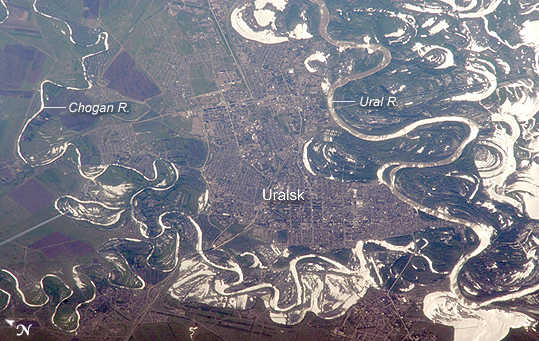 |
| Uralsk, Kazakhstan The approximate boundary between Europe and Asia is defined by the Ural River and the Ural Mountains to its north. The Ural River flows to the great, inland Caspian Sea, and gives its name to the city of Uralsk on its banks. Lying just inside the Kazakh border with Russia, Uralsk is an agricultural and industrial center, and has been an important trade stop since the early 1600s. Barge traffic has passed up and down the Ural River between the Caspian Sea and the Ural Mountains for centuries. Today it is one of the major entry points for rail traffic from Europe to Siberia, servicing the many new oil fields in the Caspian basin and the industrial cities of the southern Urals. International Space Station astronauts acquired a series of images of Uralsk, highlighting the city under different lighting conditions. This view shows the sunglint (light reflected from the water surface towards the observer) on the rivers, lakes, and ponds of the Ural floodplain (right side of image) and that of a tributary, the Chogan River (bottom). The cityscape of Uralsk, on the headland between the two, is relatively difficult to see because the water and sunglint dominate the scene. |
| Images: | All Available Images Low-Resolution 308k |
|
| Mission: | ISS011 |
|
| Roll - Frame: | E - 6717 |
|
| Geographical Name: | KAZAKHSTAN |
|
| Features: | URAL'SK, URAL R., MARSH, GLINT |
|
| Center Lat x Lon: | 51.2N x 51.4E |
|
| Film Exposure: | N=Normal exposure, U=Under exposed, O=Over exposed, F=out of Focus |
|
| Percentage of Cloud Cover-CLDP: | 10 |
|
| Camera:: | N1 |
|
| Camera Tilt: | HO | LO=Low Oblique, HO=High Oblique, NV=Near Vertical |
| Camera Focal Length: | 800 |
|
| Nadir to Photo Center Direction: | W | The direction from the nadir to the center point, N=North, S=South, E=East, W=West |
| Stereo?: | Y=Yes there is an adjacent picture of the same area, N=No there isn't |
|
| Orbit Number: | 1164 |
|
| Date: | 20050522 | YYYYMMDD |
| Time: | 120843 | GMT HHMMSS |
| Nadir Lat: | 51.8N |
Latitude of suborbital point of spacecraft |
| Nadir Lon: | 58.0E |
Longitude of suborbital point of spacecraft |
| Sun Azimuth: | 260 | Clockwise angle in degrees from north to the sun measured at the nadir point |
| Space Craft Altitude: | 186 | nautical miles |
| Sun Elevation: | 34 | Angle in degrees between the horizon and the sun, measured at the nadir point |
| Land Views: | BASIN |
|
| Water Views: | RIVER, SEA, SUNGLINT |
|
| Atmosphere Views: | |
|
| Man Made Views: | |
|
| City Views: | |
|
Photo is not associated with any sequences | ||
| NASA Home Page |
JSC Home Page |
JSC Digital Image Collection |
Earth Science & Remote Sensing |
|
This service is provided by the International Space Station program and the JSC Earth Science & Remote Sensing Unit, ARES Division, Exploration Integration Science Directorate.

|