Geographic Region: EGYPT
Feature: LAKE NASSER,SUNGLINT
|
Geographic Region: EGYPT Feature: LAKE NASSER,SUNGLINT |
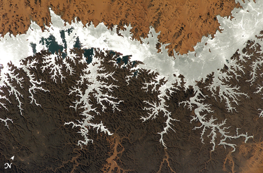 |
| ISS010-E-14618 (23 January 2005) --- Egypt's Lake Nasser, centered roughly at 22.64 degrees north latitude and 32.45 degrees east longitude, was captured with an electronic still camera by the Expedition 10 crew onboard the International Space Station. Sunglint on the lake makes it more easily visible. |
| Images: | All Available Images Low-Resolution 303k |
|
| Mission: | ISS010 |
|
| Roll - Frame: | E - 14618 |
|
| Geographical Name: | EGYPT |
|
| Features: | LAKE NASSER,SUNGLINT |
|
| Center Lat x Lon: | 22.5N x 32.5E |
|
| Film Exposure: | N=Normal exposure, U=Under exposed, O=Over exposed, F=out of Focus |
|
| Percentage of Cloud Cover-CLDP: | 10 |
|
| Camera:: | E4 |
|
| Camera Tilt: | 54 | LO=Low Oblique, HO=High Oblique, NV=Near Vertical |
| Camera Focal Length: | 400 |
|
| Nadir to Photo Center Direction: | S | The direction from the nadir to the center point, N=North, S=South, E=East, W=West |
| Stereo?: | Y=Yes there is an adjacent picture of the same area, N=No there isn't |
|
| Orbit Number: | 3292 |
|
| Date: | 20050123 | YYYYMMDD |
| Time: | 095135 | GMT HHMMSS |
| Nadir Lat: | 26.7N |
Latitude of suborbital point of spacecraft |
| Nadir Lon: | 33.8E |
Longitude of suborbital point of spacecraft |
| Sun Azimuth: | 178 | Clockwise angle in degrees from north to the sun measured at the nadir point |
| Space Craft Altitude: | 188 | nautical miles |
| Sun Elevation: | 44 | Angle in degrees between the horizon and the sun, measured at the nadir point |
| Land Views: | |
|
| Water Views: | LAKE, SUNGLINT |
|
| Atmosphere Views: | |
|
| Man Made Views: | |
|
| City Views: | |
|
Photo is not associated with any sequences | ||
| NASA Home Page |
JSC Home Page |
JSC Digital Image Collection |
Earth Science & Remote Sensing |
|
This service is provided by the International Space Station program and the JSC Earth Science & Remote Sensing Unit, ARES Division, Exploration Integration Science Directorate.

|