Geographic Region: KAZAKHSTAN
Feature: URAL RIVER DELTA, CANALS
|
Geographic Region: KAZAKHSTAN Feature: URAL RIVER DELTA, CANALS |
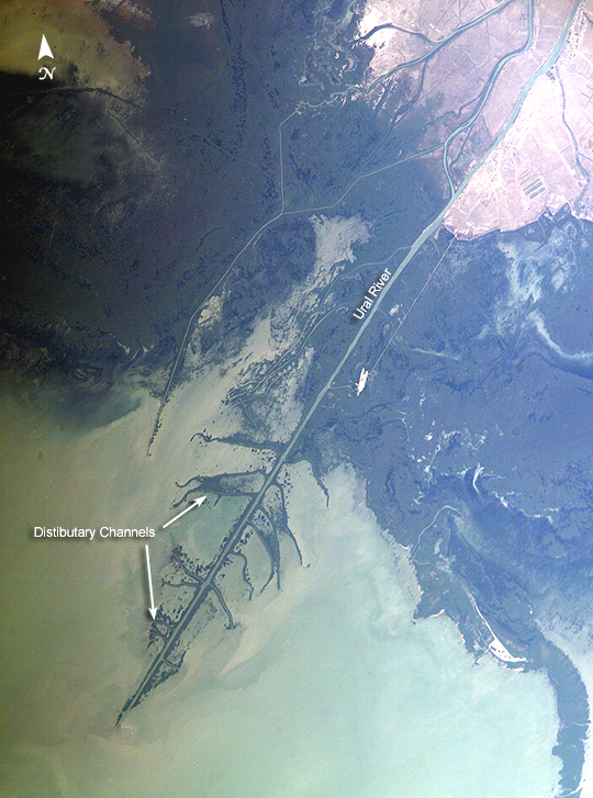 |
| Ural River Delta, Kazakhstan The Ural River is one of the two major rivers (the other is the Volga) that empty into the northern coast of the Caspian Sea, creating extensive wetlands. This image shows details of the Ural's tree-like (or "digitate") delta. This type of delta forms when wave action is low, and sediment content in the river is high. New distributary channels form in the delta when the river breaches natural levees formed by sediment deposition. The dark regions running along the coast are the wetlands, which support high biodiversity due to the unique environment and relative isolation of the Caspian Sea. The coastal wetlands are especially important to migrating birds as an important stop-over along the Asian flyway. The Ural River's trek to the Caspian is long --roughly 2,400 kilometers (1,500 miles) southward from the Ural Mountains in Russia to empty into the northern Caspian Sea in Kazakhstan. Although the current sea level of the Caspian is more than 26 meters below global mean sea level, the water levels have risen roughly 2 meters since 1980. This increase has caused flooding of much of the coastal region, including the Ural Delta, and it endangers these coastal wetland environments. The coastal flooding has also impacted the oil exploration infrastructure bordering the Caspian coastline. |
| Images: | All Available Images Low-Resolution 526k |
|
| Mission: | ISS009 |
|
| Roll - Frame: | E - 18679 |
|
| Geographical Name: | KAZAKHSTAN |
|
| Features: | URAL RIVER DELTA, CANALS |
|
| Center Lat x Lon: | 46.9N x 51.7E |
|
| Film Exposure: | N=Normal exposure, U=Under exposed, O=Over exposed, F=out of Focus |
|
| Percentage of Cloud Cover-CLDP: | 10 |
|
| Camera:: | E4 |
|
| Camera Tilt: | HO | LO=Low Oblique, HO=High Oblique, NV=Near Vertical |
| Camera Focal Length: | 400 |
|
| Nadir to Photo Center Direction: | E | The direction from the nadir to the center point, N=North, S=South, E=East, W=West |
| Stereo?: | Y=Yes there is an adjacent picture of the same area, N=No there isn't |
|
| Orbit Number: | 792 |
|
| Date: | 20040817 | YYYYMMDD |
| Time: | 075203 | GMT HHMMSS |
| Nadir Lat: | 48.4N |
Latitude of suborbital point of spacecraft |
| Nadir Lon: | 47.3E |
Longitude of suborbital point of spacecraft |
| Sun Azimuth: | 154 | Clockwise angle in degrees from north to the sun measured at the nadir point |
| Space Craft Altitude: | 187 | nautical miles |
| Sun Elevation: | 53 | Angle in degrees between the horizon and the sun, measured at the nadir point |
| Land Views: | COAST |
|
| Water Views: | DELTA, FLOODING, RIVER, SEA, SEDIMENT, WAVE |
|
| Atmosphere Views: | |
|
| Man Made Views: | |
|
| City Views: | |
|
Photo is not associated with any sequences | ||
| NASA Home Page |
JSC Home Page |
JSC Digital Image Collection |
Earth Science & Remote Sensing |
|
This service is provided by the International Space Station program and the JSC Earth Science & Remote Sensing Unit, ARES Division, Exploration Integration Science Directorate.

|