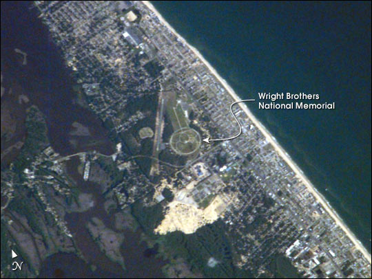
 Photo #: ISS007-E-7842 Date: Jun. 2003
Geographic Region: USA-NORTH CAROLINA
Feature: KILL DEVIL HILL, KITTY HAWK

 Photo #: ISS007-E-7842 Date: Jun. 2003 Photo #: ISS007-E-7842 Date: Jun. 2003Geographic Region: USA-NORTH CAROLINA Feature: KILL DEVIL HILL, KITTY HAWK |
 |
| This year the world celebrates a century of human flight with the one hundredth anniversary of the Wright Brothers' first flight at Kitty Hawk, North Carolina. Astronauts aboard the International Space Station share a kindred spirit of flight accomplishments and commemorated the centennial celebration (//www.firstflightcentennial.org/) with this image of Kitty Hawk and the Wright Brothers National Memorial. Kitty Hawk is located on North Carolina's Outer Banks. The Wrights used the Outer Banks' prevailing winds and the altitude gained by climbing a 90-foot hill (Kill Devil Hill) to successfully demonstrate powered flight. The large circle on the image is a road ringing Kill Devil Hill, now part of the Wright Brothers National Memorial. A large granite monument sits on top of the hill. Both the Wright Brothers National Memorial and Dayton, Ohio (hometown of the Wright Brothers) will host celebrations of the Wright Brothers' achievement throughout the year. |
| Images: | All Available Images Low-Resolution 57k |
|
| Mission: | ISS007 |
|
| Roll - Frame: | E - 7842 |
|
| Geographical Name: | USA-NORTH CAROLINA |
|
| Features: | KILL DEVIL HILL, KITTY HAWK |
|
| Center Lat x Lon: | 36.0N x 75.5W |
|
| Film Exposure: | N=Normal exposure, U=Under exposed, O=Over exposed, F=out of Focus |
|
| Percentage of Cloud Cover-CLDP: | 10 |
|
| Camera:: | E4 |
|
| Camera Tilt: | 30 | LO=Low Oblique, HO=High Oblique, NV=Near Vertical |
| Camera Focal Length: | 800 |
|
| Nadir to Photo Center Direction: | S | The direction from the nadir to the center point, N=North, S=South, E=East, W=West |
| Stereo?: | Y=Yes there is an adjacent picture of the same area, N=No there isn't |
|
| Orbit Number: | 2184 |
|
| Date: | 20030622 | YYYYMMDD |
| Time: | 130608 | GMT HHMMSS |
| Nadir Lat: | 38.0N |
Latitude of suborbital point of spacecraft |
| Nadir Lon: | 75.6W |
Longitude of suborbital point of spacecraft |
| Sun Azimuth: | 88 | Clockwise angle in degrees from north to the sun measured at the nadir point |
| Space Craft Altitude: | 208 | nautical miles |
| Sun Elevation: | 38 | Angle in degrees between the horizon and the sun, measured at the nadir point |
| Land Views: | HILL |
|
| Water Views: | |
|
| Atmosphere Views: | |
|
| Man Made Views: | |
|
| City Views: | DAYTON |
|
Photo is not associated with any sequences | ||
| NASA Home Page |
JSC Home Page |
JSC Digital Image Collection |
Earth Science & Remote Sensing |
|
|