Geographic Region: RUSSIAN FEDERATION
Feature: KULUNDA STEPPE, OB RIVER, SNOW
|
Geographic Region: RUSSIAN FEDERATION Feature: KULUNDA STEPPE, OB RIVER, SNOW |
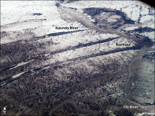 |
| The dark spikes slashing across this agricultural area between the Ob River and the Irtysh River (out of the view left) form a familiar visual cue for astronauts that they are flying over Western Siberia. The signature pattern across the center is made by forests in a great plain that has been folded by tectonic forces--the surface rock layers form a long series of gentle folds aligned NE-SW. The lower zones are darker because the snow disappears through the Scotch pine trees. The higher areas are occupied by numerous angular fields of the steppe, etched by snow. The Ob is a major river of Siberia, draining from the Altai Mountains on the borders of western China and Mongolia in central Asia, thousands of miles to the Arctic Ocean. Great bends in a 300-km stretch of the Ob River appear on the right side of this north-looking view image (taken with a 50 mm lens, April 10, 2003). The major Siberian city of Barnaul is the dark patch on a sharp bend in the Ob River (right margin). Barnaul is a major industrial and cultural center, but began as one of Russia's most famous two mining cities, having supplied hundreds of tons of silver to the imperial coffers since the mid 1700s. Barnaul lies 200 km south of Novosibirsk, one of the most important cities on the Trans-Siberian railroad. |
| Images: | All Available Images Low-Resolution 88k |
|
| Mission: | ISS006 |
|
| Roll - Frame: | E - 45591 |
|
| Geographical Name: | RUSSIAN FEDERATION |
|
| Features: | KULUNDA STEPPE, OB RIVER, SNOW |
|
| Center Lat x Lon: | 53.0N x 82.5E |
|
| Film Exposure: | N=Normal exposure, U=Under exposed, O=Over exposed, F=out of Focus |
|
| Percentage of Cloud Cover-CLDP: | 10 |
|
| Camera:: | E4 |
|
| Camera Tilt: | HO | LO=Low Oblique, HO=High Oblique, NV=Near Vertical |
| Camera Focal Length: | 50 |
|
| Nadir to Photo Center Direction: | W | The direction from the nadir to the center point, N=North, S=South, E=East, W=West |
| Stereo?: | Y=Yes there is an adjacent picture of the same area, N=No there isn't |
|
| Orbit Number: | 1043 |
|
| Date: | 20030410 | YYYYMMDD |
| Time: | 095632 | GMT HHMMSS |
| Nadir Lat: | 50.7N |
Latitude of suborbital point of spacecraft |
| Nadir Lon: | 87.2E |
Longitude of suborbital point of spacecraft |
| Sun Azimuth: | 247 | Clockwise angle in degrees from north to the sun measured at the nadir point |
| Space Craft Altitude: | 206 | nautical miles |
| Sun Elevation: | 27 | Angle in degrees between the horizon and the sun, measured at the nadir point |
| Land Views: | PLAIN |
|
| Water Views: | RIVER |
|
| Atmosphere Views: | |
|
| Man Made Views: | MINING |
|
| City Views: | BARNAUL |
|
Photo is not associated with any sequences | ||
| NASA Home Page |
JSC Home Page |
JSC Digital Image Collection |
Earth Science & Remote Sensing |
|
This service is provided by the International Space Station program and the JSC Earth Science & Remote Sensing Unit, ARES Division, Exploration Integration Science Directorate.

|