Geographic Region: CHINA
Feature: BAITOUSHAN VOLCANO
|
Geographic Region: CHINA Feature: BAITOUSHAN VOLCANO |
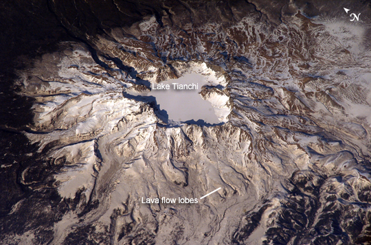 |
| Baitoushan Volcano, China and North Korea One of the largest known eruptions of the modern geologic period (the Holocene) occurred at Baitoushan Volcano (also known as Changbaishan in China and P'aektu-san in Korea) about 1000 A.D., with erupted material deposited as far away as northern Japan--a distance of approximately 1,200 kilometers. The eruption also created the 4.5-kilometer-diameter, 850-meter-deep summit caldera of the volcano, which is now filled with the waters of Lake Tianchi (or Sky Lake). This oblique astronaut photograph was taken during the winter season, and snow highlights frozen Lake Tianchi and lava flow lobes along the southern face of the volcano. Baitoushan last erupted in 1702, and geologists consider it to be dormant. Gas emissions were reported from the summit and nearby hot springs in 1994, but no evidence of renewed activity of the volcano was observed. The Chinese-Korean border runs directly through the center of the summit caldera, and the mountain is considered sacred by the predominantly Korean population living near the volcano. Lake Tianchi is a popular resort destination, both for its natural beauty and alleged sightings of unidentified creatures living in its depths (similar to the legendary Loch Ness Monster in Scotland). |
| Images: | All Available Images Low-Resolution 288k |
|
| Mission: | ISS006 |
|
| Roll - Frame: | E - 43366 |
|
| Geographical Name: | CHINA |
|
| Features: | BAITOUSHAN VOLCANO |
|
| Center Lat x Lon: | 42.0N x 128.0E |
|
| Film Exposure: | N=Normal exposure, U=Under exposed, O=Over exposed, F=out of Focus |
|
| Percentage of Cloud Cover-CLDP: | 10 |
|
| Camera:: | E4 |
|
| Camera Tilt: | 27 | LO=Low Oblique, HO=High Oblique, NV=Near Vertical |
| Camera Focal Length: | 800 |
|
| Nadir to Photo Center Direction: | NE | The direction from the nadir to the center point, N=North, S=South, E=East, W=West |
| Stereo?: | Y=Yes there is an adjacent picture of the same area, N=No there isn't |
|
| Orbit Number: | 948 |
|
| Date: | 20030404 | YYYYMMDD |
| Time: | 074020 | GMT HHMMSS |
| Nadir Lat: | 40.8N |
Latitude of suborbital point of spacecraft |
| Nadir Lon: | 126.8E |
Longitude of suborbital point of spacecraft |
| Sun Azimuth: | 255 | Clockwise angle in degrees from north to the sun measured at the nadir point |
| Space Craft Altitude: | 204 | nautical miles |
| Sun Elevation: | 25 | Angle in degrees between the horizon and the sun, measured at the nadir point |
| Land Views: | CALDERA, MOUNTAIN, VOLCANO |
|
| Water Views: | LAKE |
|
| Atmosphere Views: | |
|
| Man Made Views: | RESORT |
|
| City Views: | |
|
Photo is not associated with any sequences | ||
| NASA Home Page |
JSC Home Page |
JSC Digital Image Collection |
Earth Science & Remote Sensing |
|
This service is provided by the International Space Station program and the JSC Earth Science & Remote Sensing Unit, ARES Division, Exploration Integration Science Directorate.

|