Geographic Region: PERU
Feature: COASTLINE, ANDES RANGE
|
Geographic Region: PERU Feature: COASTLINE, ANDES RANGE |
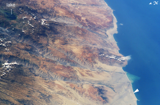 |
| Arid Coast of Peru Following the last major upheaval of the Andes Mountains, rivers flowing down into the Pacific Ocean have carved dramatic canyons along Peru's southern coast. In geologic terms, the canyons are relatively young--carved over the past 8 million years. This oblique (off-vertical) image from March 14, 2003, provides a southward look down Peru's rugged, arid coastline between 15.5 and 17 degrees South latitude. The canyons run from left to right and appear grayer than the surrounding reddish-brown terrain. The canyons found here are some of the deepest and steepest on Earth--lake Laguna Parincocha (top left corner) lies on the Andean plateau about 3,250 meters (10,700 feet) above sea level, about 80 kilometers (50 miles) from the coast. At lower left, a dense pattern of parallel grooves has been carved into a sheet of volcanic rock by now-dry streams. The volcanic rock is a kind called ignimbrite, which is the result of an eruption of hot gases and small rock fragments that flow from the volcano like a fluid (a pyroclastic flow). In an ignimbrite, the rock fragments are mostly pumice, a lightweight volcanic glass full of cavities. The Yauca and Acari rivers feed small, tan-colored sediment plumes into the sea (lower right). Dark green agricultural fields cluster along the lower courses of the rivers. Strong southerly winds have generated sand dunes and dark wind streaks along the coast, whose alignments re-curve inland into the lower river valleys (lower right). The coast and canyons are commonly hazy due to oceanic air and blowing dust. Yellow lines parallel with the coast and near the small peninsula are raised shorelines probably caused by tectonic uplift of the coastline. |
| Images: | All Available Images Low-Resolution 239k |
|
| Mission: | ISS006 |
|
| Roll - Frame: | E - 38306 |
|
| Geographical Name: | PERU |
|
| Features: | COASTLINE, ANDES RANGE |
|
| Center Lat x Lon: | 15.5S x 74W |
|
| Film Exposure: | N=Normal exposure, U=Under exposed, O=Over exposed, F=out of Focus |
|
| Percentage of Cloud Cover-CLDP: | 10 |
|
| Camera:: | E4 |
|
| Camera Tilt: | HO | LO=Low Oblique, HO=High Oblique, NV=Near Vertical |
| Camera Focal Length: | 180 |
|
| Nadir to Photo Center Direction: | SE | The direction from the nadir to the center point, N=North, S=South, E=East, W=West |
| Stereo?: | Y=Yes there is an adjacent picture of the same area, N=No there isn't |
|
| Orbit Number: | 625 |
|
| Date: | 20030314 | YYYYMMDD |
| Time: | 152310 | GMT HHMMSS |
| Nadir Lat: | 8.9S |
Latitude of suborbital point of spacecraft |
| Nadir Lon: | 80.5W |
Longitude of suborbital point of spacecraft |
| Sun Azimuth: | 81 | Clockwise angle in degrees from north to the sun measured at the nadir point |
| Space Craft Altitude: | 215 | nautical miles |
| Sun Elevation: | 58 | Angle in degrees between the horizon and the sun, measured at the nadir point |
| Land Views: | COAST, PENINSULA, PLATEAU, VOLCANO |
|
| Water Views: | LAKE, OCEAN, RIVER, SEA, SEDIMENT |
|
| Atmosphere Views: | DUST |
|
| Man Made Views: | |
|
| City Views: | |
|
Photo is not associated with any sequences | ||
| NASA Home Page |
JSC Home Page |
JSC Digital Image Collection |
Earth Science & Remote Sensing |
|
This service is provided by the International Space Station program and the JSC Earth Science & Remote Sensing Unit, ARES Division, Exploration Integration Science Directorate.

|