
Geographic Region: USA-MICHIGAN
Feature: LAKE MICHIGAN, ICE, SNOW
|
Geographic Region: USA-MICHIGAN Feature: LAKE MICHIGAN, ICE, SNOW |
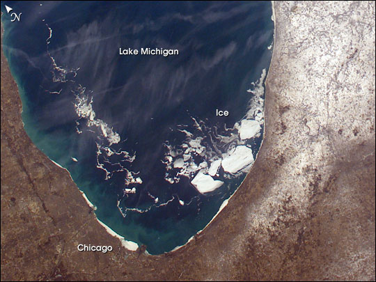 |
| A colder than normal North American winter saw the entire surface areas of Lakes Superior, Huron, and Erie frozen over for the first time in years. The cold has delayed the opening of the St. Lawrence Seaway and will likely delay the start of the growing season near the Great Lake shorelines. Although the open surface waters of Lake Michigan did not freeze this season, the southern portion experienced a higher than normal amount of ice. Winds and currents drove broken pieces of ice from the north to the south. This image taken from the International Space Station shows a number of large pieces of ice collected along and just off the shoreline southwest of Benton Harbor, Michigan. Smaller pieces trail northward offshore from Chicago, Illinois. Note the ice accumulation along the entire eastern shoreline of Lake Michigan as well as the wind-drive lake-effect snow cover over the western half of the lower Michigan Peninsula. |
| Images: | All Available Images Low-Resolution 67k |
|
| Mission: | ISS006 |
|
| Roll - Frame: | E - 29393 |
|
| Geographical Name: | USA-MICHIGAN |
|
| Features: | LAKE MICHIGAN, ICE, SNOW |
|
| Center Lat x Lon: | 42.5N x 86W |
|
| Film Exposure: | N=Normal exposure, U=Under exposed, O=Over exposed, F=out of Focus |
|
| Percentage of Cloud Cover-CLDP: | 10 |
|
| Camera:: | E4 |
|
| Camera Tilt: | 48 | LO=Low Oblique, HO=High Oblique, NV=Near Vertical |
| Camera Focal Length: | 28 |
|
| Nadir to Photo Center Direction: | E | The direction from the nadir to the center point, N=North, S=South, E=East, W=West |
| Stereo?: | Y=Yes there is an adjacent picture of the same area, N=No there isn't |
|
| Orbit Number: | 301 |
|
| Date: | 20030221 | YYYYMMDD |
| Time: | 203846 | GMT HHMMSS |
| Nadir Lat: | 43.5N |
Latitude of suborbital point of spacecraft |
| Nadir Lon: | 89.8W |
Longitude of suborbital point of spacecraft |
| Sun Azimuth: | 221 | Clockwise angle in degrees from north to the sun measured at the nadir point |
| Space Craft Altitude: | 210 | nautical miles |
| Sun Elevation: | 27 | Angle in degrees between the horizon and the sun, measured at the nadir point |
| Land Views: | PENINSULA |
|
| Water Views: | ICE, LAKE |
|
| Atmosphere Views: | |
|
| Man Made Views: | |
|
| City Views: | CHICAGO |
|
Photo is not associated with any sequences | ||
| NASA Home Page |
JSC Home Page |
JSC Digital Image Collection |
Earth Science & Remote Sensing |
|
This service is provided by the International Space Station program and the JSC Earth Science & Remote Sensing Unit, ARES Division, Exploration Integration Science Directorate.

|