Geographic Region: RUSSIAN FEDERATION
Feature: MOUNT ELBRUS
|
Geographic Region: RUSSIAN FEDERATION Feature: MOUNT ELBRUS |
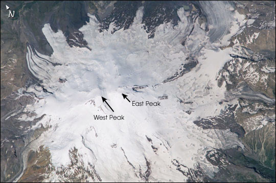 |
| The Caucasus Mountains form a long (more than 1200 km) and steep spine connecting the Black Sea to the Caspian. Mt. Elbrus, the summit of the Caucasus Mountains, is located in southern Russia just north of the Georgian border, and is distinguished as Europe's highest peak (5642 m). Elbrus is also an ancient volcano, although it has not erupted for nearly 2000 years. Elbrus' profile comprises two volcanic peaks (East and West). They are popular trekking and mountain climbing destinations' the saddle between them provides access to the region. In mid-September, the Russian and American crew aboard the International Space Station viewed Mt. Elbrus' glaciated landscape as part of a study by Russian glaciologists. Elbrus is located west of the recent lacier slide on Mt. Kazbek, another giant peak in the Caucasus Mountains. |
| Images: | All Available Images Low-Resolution 50k |
|
| Mission: | ISS005 |
|
| Roll - Frame: | E - 9675 |
|
| Geographical Name: | RUSSIAN FEDERATION |
|
| Features: | MOUNT ELBRUS |
|
| Center Lat x Lon: | 43.5N x 42.5E |
|
| Film Exposure: | N=Normal exposure, U=Under exposed, O=Over exposed, F=out of Focus |
|
| Percentage of Cloud Cover-CLDP: | 10 |
|
| Camera:: | E4 |
|
| Camera Tilt: | 29 | LO=Low Oblique, HO=High Oblique, NV=Near Vertical |
| Camera Focal Length: | 800 |
|
| Nadir to Photo Center Direction: | N | The direction from the nadir to the center point, N=North, S=South, E=East, W=West |
| Stereo?: | Y=Yes there is an adjacent picture of the same area, N=No there isn't |
|
| Orbit Number: | 1300 |
|
| Date: | 20020813 | YYYYMMDD |
| Time: | 110633 | GMT HHMMSS |
| Nadir Lat: | 41.7N |
Latitude of suborbital point of spacecraft |
| Nadir Lon: | 41.7E |
Longitude of suborbital point of spacecraft |
| Sun Azimuth: | 229 | Clockwise angle in degrees from north to the sun measured at the nadir point |
| Space Craft Altitude: | 209 | nautical miles |
| Sun Elevation: | 54 | Angle in degrees between the horizon and the sun, measured at the nadir point |
| Land Views: | MOUNTAIN, VOLCANO |
|
| Water Views: | |
|
| Atmosphere Views: | |
|
| Man Made Views: | |
|
| City Views: | |
|
Photo is not associated with any sequences | ||
| NASA Home Page |
JSC Home Page |
JSC Digital Image Collection |
Earth Science & Remote Sensing |
|
This service is provided by the International Space Station program and the JSC Earth Science & Remote Sensing Unit, ARES Division, Exploration Integration Science Directorate.

|