Geographic Region: CHINA
Feature: MOUNT EVEREST, LHOTSE PEAK
|
Geographic Region: CHINA Feature: MOUNT EVEREST, LHOTSE PEAK |
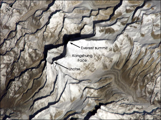 |
| Astronaut Dan Bursch, a member of the Expedition 4 crew on the International Space Station, observed Mt. Everest in late March 2002. This detailed image of Everest, the highest (29,035 feet, 8850 meters) mountain in the world, shows early morning light on the eastern Kangshung Face. The mountains appear to jump out of the picture because the image was taken with low sunlight using an electronic still camera equipped with an 800 mm lens. Astronaut Bursch describes passing over Mt. Everest as part of his 120-day report. |
| Images: | All Available Images Low-Resolution 63k |
|
| Mission: | ISS004 |
|
| Roll - Frame: | E - 8852 |
|
| Geographical Name: | CHINA |
|
| Features: | MOUNT EVEREST, LHOTSE PEAK |
|
| Center Lat x Lon: | 28.0N x 86.5E |
|
| Film Exposure: | N=Normal exposure, U=Under exposed, O=Over exposed, F=out of Focus |
|
| Percentage of Cloud Cover-CLDP: | 10 |
|
| Camera:: | E4 |
|
| Camera Tilt: | 50 | LO=Low Oblique, HO=High Oblique, NV=Near Vertical |
| Camera Focal Length: | 800 |
|
| Nadir to Photo Center Direction: | SW | The direction from the nadir to the center point, N=North, S=South, E=East, W=West |
| Stereo?: | Y=Yes there is an adjacent picture of the same area, N=No there isn't |
|
| Orbit Number: | 3016 |
|
| Date: | 20020320 | YYYYMMDD |
| Time: | 014419 | GMT HHMMSS |
| Nadir Lat: | 29.9N |
Latitude of suborbital point of spacecraft |
| Nadir Lon: | 90.2E |
Longitude of suborbital point of spacecraft |
| Sun Azimuth: | 103 | Clockwise angle in degrees from north to the sun measured at the nadir point |
| Space Craft Altitude: | 213 | nautical miles |
| Sun Elevation: | 21 | Angle in degrees between the horizon and the sun, measured at the nadir point |
| Land Views: | MOUNTAIN |
|
| Water Views: | |
|
| Atmosphere Views: | |
|
| Man Made Views: | |
|
| City Views: | |
|
Photo is not associated with any sequences | ||
| NASA Home Page |
JSC Home Page |
JSC Digital Image Collection |
Earth Science & Remote Sensing |
|
This service is provided by the International Space Station program and the JSC Earth Science & Remote Sensing Unit, ARES Division, Exploration Integration Science Directorate.

|