Geographic Region: GUATEMALA
Feature: SANTA MARIA VOLCANO, SMOKE
|
Geographic Region: GUATEMALA Feature: SANTA MARIA VOLCANO, SMOKE |
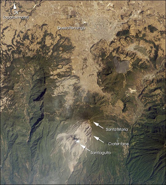 |
| The eruption of Santa Maria volcano in 1902 was one of the largest eruptions of the 20th century, forming a large crater on the mountain's southwest flank. Since 1922, a lava-dome complex, Santiaguito, has been forming in the 1902 crater. Growth of the dome has produced pyroclastic flows as recently as the 2001--they can be identified in this image. The city of Quezaltenango (approximately 90,000 people in 1989) sits below the 3772 m summit. The volcano is considered dangerous because of the possibility of a dome collapse such as one that occurred in 1929, which killed about 5000 people. A second hazard results from the flow of volcanic debris into rivers south of Santiaguito, which can lead to catastrophic flooding and mud flows. |
| Images: | All Available Images Low-Resolution 88k |
|
| Mission: | ISS004 |
|
| Roll - Frame: | E - 7999 |
|
| Geographical Name: | GUATEMALA |
|
| Features: | SANTA MARIA VOLCANO, SMOKE |
|
| Center Lat x Lon: | 15.0N x 91.5W |
|
| Film Exposure: | N=Normal exposure, U=Under exposed, O=Over exposed, F=out of Focus |
|
| Percentage of Cloud Cover-CLDP: | 10 |
|
| Camera:: | E4 |
|
| Camera Tilt: | HO | LO=Low Oblique, HO=High Oblique, NV=Near Vertical |
| Camera Focal Length: | 400 |
|
| Nadir to Photo Center Direction: | SW | The direction from the nadir to the center point, N=North, S=South, E=East, W=West |
| Stereo?: | Y=Yes there is an adjacent picture of the same area, N=No there isn't |
|
| Orbit Number: | 2542 |
|
| Date: | 20020217 | YYYYMMDD |
| Time: | 164104 | GMT HHMMSS |
| Nadir Lat: | 20.9N |
Latitude of suborbital point of spacecraft |
| Nadir Lon: | 86.7W |
Longitude of suborbital point of spacecraft |
| Sun Azimuth: | 147 | Clockwise angle in degrees from north to the sun measured at the nadir point |
| Space Craft Altitude: | 205 | nautical miles |
| Sun Elevation: | 52 | Angle in degrees between the horizon and the sun, measured at the nadir point |
| Land Views: | CRATER, MOUNTAIN, VOLCANO |
|
| Water Views: | |
|
| Atmosphere Views: | |
|
| Man Made Views: | |
|
| City Views: | QUEZALTENANGO |
|
Photo is not associated with any sequences | ||
| NASA Home Page |
JSC Home Page |
JSC Digital Image Collection |
Earth Science & Remote Sensing |
|
This service is provided by the International Space Station program and the JSC Earth Science & Remote Sensing Unit, ARES Division, Exploration Integration Science Directorate.

|